You are here: Home > Network List > AV - Alaska Volcano Observatory Stations List
> Station SPCR Ckakachatna River, Mount Spurr, Alaska > Earthquake Result Viewer
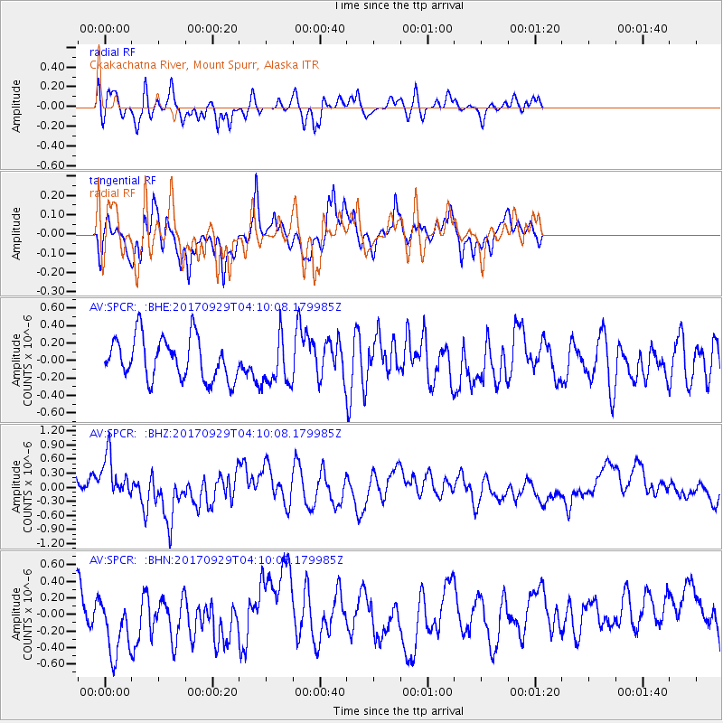
SPCR Ckakachatna River, Mount Spurr, Alaska - Earthquake Result Viewer
*The percent match for this event was below the threshold and hence no stack was calculated.
| Earthquake location: |
Off Coast Of Chiapas, Mexico |
| Earthquake latitude/longitude: |
14.9/-94.0 |
| Earthquake time(UTC): |
2017/09/29 (272) 04:00:22 GMT |
| Earthquake Depth: |
22 km |
| Earthquake Magnitude: |
5.6 mb |
| Earthquake Catalog/Contributor: |
NEIC PDE/us |
|
| Network: |
AV Alaska Volcano Observatory |
| Station: |
SPCR Ckakachatna River, Mount Spurr, Alaska |
| Lat/Lon: |
61.20 N/152.21 W |
| Elevation: |
984 m |
|
| Distance: |
61.9 deg |
| Az: |
332.21 deg |
| Baz: |
111.434 deg |
| Ray Param: |
$rayparam |
*The percent match for this event was below the threshold and hence was not used in the summary stack. |
|
| Radial Match: |
55.132183 % |
| Radial Bump: |
400 |
| Transverse Match: |
59.659756 % |
| Transverse Bump: |
400 |
| SOD ConfigId: |
13570011 |
| Insert Time: |
2019-04-28 21:50:30.622 +0000 |
| GWidth: |
2.5 |
| Max Bumps: |
400 |
| Tol: |
0.001 |
|
Signal To Noise
| Channel | StoN | STA | LTA |
| AV:SPCR: :BHZ:20170929T04:10:08.179985Z | 2.1245997 | 4.808902E-7 | 2.2634391E-7 |
| AV:SPCR: :BHN:20170929T04:10:08.179985Z | 1.7383842 | 3.9006304E-7 | 2.2438252E-7 |
| AV:SPCR: :BHE:20170929T04:10:08.179985Z | 1.181068 | 2.8327494E-7 | 2.3984643E-7 |
| Arrivals |
| Ps | |
| PpPs | |
| PsPs/PpSs | |


