You are here: Home > Network List > US - United States National Seismic Network Stations List
> Station WMOK Wichita Mountains, Oklahoma, USA > Earthquake Result Viewer
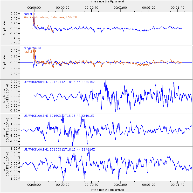
WMOK Wichita Mountains, Oklahoma, USA - Earthquake Result Viewer
*The percent match for this event was below the threshold and hence no stack was calculated.
| Earthquake location: |
Andreanof Islands, Aleutian Is. |
| Earthquake latitude/longitude: |
51.6/-174.0 |
| Earthquake time(UTC): |
2016/03/12 (072) 18:06:45 GMT |
| Earthquake Depth: |
19 km |
| Earthquake Magnitude: |
6.3 MWW, 6.1 MB, 6.2 MWB, 6.3 MWC, 6.4 MWC, 6.4 MI |
| Earthquake Catalog/Contributor: |
NEIC PDE/NEIC COMCAT |
|
| Network: |
US United States National Seismic Network |
| Station: |
WMOK Wichita Mountains, Oklahoma, USA |
| Lat/Lon: |
34.74 N/98.78 W |
| Elevation: |
486 m |
|
| Distance: |
55.0 deg |
| Az: |
76.565 deg |
| Baz: |
312.503 deg |
| Ray Param: |
$rayparam |
*The percent match for this event was below the threshold and hence was not used in the summary stack. |
|
| Radial Match: |
74.05677 % |
| Radial Bump: |
400 |
| Transverse Match: |
79.303925 % |
| Transverse Bump: |
400 |
| SOD ConfigId: |
1453031 |
| Insert Time: |
2016-03-26 18:40:00.364 +0000 |
| GWidth: |
2.5 |
| Max Bumps: |
400 |
| Tol: |
0.001 |
|
Signal To Noise
| Channel | StoN | STA | LTA |
| US:WMOK:00:BHZ:20160312T18:15:44.224016Z | 2.0783763 | 3.0935604E-7 | 1.4884506E-7 |
| US:WMOK:00:BH1:20160312T18:15:44.224016Z | 1.9977306 | 2.7073366E-7 | 1.355206E-7 |
| US:WMOK:00:BH2:20160312T18:15:44.224016Z | 1.4245259 | 1.7712289E-7 | 1.2433814E-7 |
| Arrivals |
| Ps | |
| PpPs | |
| PsPs/PpSs | |


