You are here: Home > Network List > TA - USArray Transportable Network (new EarthScope stations) Stations List
> Station J20K Nowitna River, AK, USA > Earthquake Result Viewer
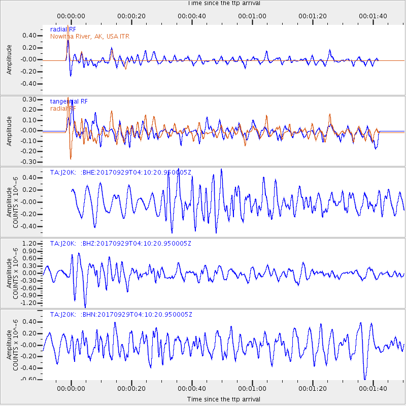
J20K Nowitna River, AK, USA - Earthquake Result Viewer
*The percent match for this event was below the threshold and hence no stack was calculated.
| Earthquake location: |
Off Coast Of Chiapas, Mexico |
| Earthquake latitude/longitude: |
14.9/-94.0 |
| Earthquake time(UTC): |
2017/09/29 (272) 04:00:22 GMT |
| Earthquake Depth: |
22 km |
| Earthquake Magnitude: |
5.6 mb |
| Earthquake Catalog/Contributor: |
NEIC PDE/us |
|
| Network: |
TA USArray Transportable Network (new EarthScope stations) |
| Station: |
J20K Nowitna River, AK, USA |
| Lat/Lon: |
64.18 N/154.15 W |
| Elevation: |
314 m |
|
| Distance: |
63.8 deg |
| Az: |
334.976 deg |
| Baz: |
110.975 deg |
| Ray Param: |
$rayparam |
*The percent match for this event was below the threshold and hence was not used in the summary stack. |
|
| Radial Match: |
68.30536 % |
| Radial Bump: |
400 |
| Transverse Match: |
53.653343 % |
| Transverse Bump: |
400 |
| SOD ConfigId: |
13570011 |
| Insert Time: |
2019-04-28 21:54:54.930 +0000 |
| GWidth: |
2.5 |
| Max Bumps: |
400 |
| Tol: |
0.001 |
|
Signal To Noise
| Channel | StoN | STA | LTA |
| TA:J20K: :BHZ:20170929T04:10:20.950005Z | 2.8356574 | 6.716274E-7 | 2.3685068E-7 |
| TA:J20K: :BHN:20170929T04:10:20.950005Z | 1.0801868 | 1.310206E-7 | 1.2129439E-7 |
| TA:J20K: :BHE:20170929T04:10:20.950005Z | 1.858856 | 3.063689E-7 | 1.6481584E-7 |
| Arrivals |
| Ps | |
| PpPs | |
| PsPs/PpSs | |


