You are here: Home > Network List > UW - Pacific Northwest Regional Seismic Network Stations List
> Station UMAT Pilot Rock, OR, USA > Earthquake Result Viewer
UMAT Pilot Rock, OR, USA - Earthquake Result Viewer
*The percent match for this event was below the threshold and hence no stack was calculated.
| Earthquake location: |
Off Coast Of Chiapas, Mexico |
| Earthquake latitude/longitude: |
14.9/-94.0 |
| Earthquake time(UTC): |
2017/09/29 (272) 04:00:22 GMT |
| Earthquake Depth: |
22 km |
| Earthquake Magnitude: |
5.6 mb |
| Earthquake Catalog/Contributor: |
NEIC PDE/us |
|
| Network: |
UW Pacific Northwest Regional Seismic Network |
| Station: |
UMAT Pilot Rock, OR, USA |
| Lat/Lon: |
45.29 N/118.96 W |
| Elevation: |
1318 m |
|
| Distance: |
36.9 deg |
| Az: |
330.293 deg |
| Baz: |
137.256 deg |
| Ray Param: |
$rayparam |
*The percent match for this event was below the threshold and hence was not used in the summary stack. |
|
| Radial Match: |
68.8654 % |
| Radial Bump: |
400 |
| Transverse Match: |
65.23065 % |
| Transverse Bump: |
400 |
| SOD ConfigId: |
13570011 |
| Insert Time: |
2019-04-28 21:56:11.563 +0000 |
| GWidth: |
2.5 |
| Max Bumps: |
400 |
| Tol: |
0.001 |
|
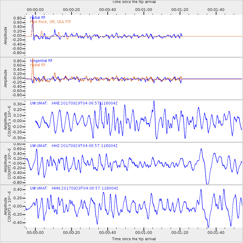
Signal To Noise
| Channel | StoN | STA | LTA |
| UW:UMAT: :HHZ:20170929T04:06:57.118004Z | 2.2171936 | 3.0741361E-7 | 1.3864988E-7 |
| UW:UMAT: :HHN:20170929T04:06:57.118004Z | 2.2283 | 1.5348533E-7 | 6.8880006E-8 |
| UW:UMAT: :HHE:20170929T04:06:57.118004Z | 1.5111616 | 1.5664801E-7 | 1.0366067E-7 |
| Arrivals |
| Ps | |
| PpPs | |
| PsPs/PpSs | |


