You are here: Home > Network List > II - Global Seismograph Network (GSN - IRIS/IDA) Stations List
> Station AAK Ala Archa, Kyrgyzstan > Earthquake Result Viewer
AAK Ala Archa, Kyrgyzstan - Earthquake Result Viewer
| Earthquake location: |
Ryukyu Islands, Japan |
| Earthquake latitude/longitude: |
29.2/129.8 |
| Earthquake time(UTC): |
2009/10/30 (303) 07:03:39 GMT |
| Earthquake Depth: |
34 km |
| Earthquake Magnitude: |
6.3 MB, 6.8 MS, 6.8 MW, 6.8 MW |
| Earthquake Catalog/Contributor: |
WHDF/NEIC |
|
| Network: |
II Global Seismograph Network (GSN - IRIS/IDA) |
| Station: |
AAK Ala Archa, Kyrgyzstan |
| Lat/Lon: |
42.64 N/74.49 E |
| Elevation: |
1645 m |
|
| Distance: |
46.0 deg |
| Az: |
302.466 deg |
| Baz: |
88.216 deg |
| Ray Param: |
0.07087048 |
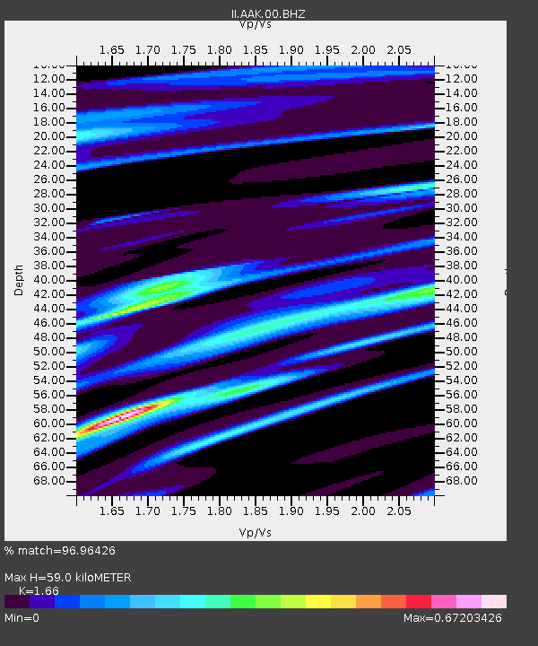
| Estimated Moho Depth: |
59.0 km |
| Estimated Crust Vp/Vs: |
1.66 |
| Assumed Crust Vp: |
6.306 km/s |
| Estimated Crust Vs: |
3.799 km/s |
| Estimated Crust Poisson's Ratio: |
0.22 |
|
| Radial Match: |
96.96426 % |
| Radial Bump: |
400 |
| Transverse Match: |
93.32554 % |
| Transverse Bump: |
400 |
| SOD ConfigId: |
1 |
| Insert Time: |
2010-02-19 00:59:51.338 +0000 |
| GWidth: |
2.5 |
| Max Bumps: |
400 |
| Tol: |
0.001 |
|

Signal To Noise
| Channel | StoN | STA | LTA |
| II:AAK:00:BHZ:20091030T07:11:28.370Z | 29.826424 | 2.0910832E-6 | 7.0108406E-8 |
| II:AAK:00:BHN:20091030T07:11:28.370Z | 10.505395 | 3.8340931E-7 | 3.649642E-8 |
| II:AAK:00:BHE:20091030T07:11:28.370Z | 16.516077 | 9.863597E-7 | 5.972119E-8 |
| Arrivals |
| Ps | 6.6 SECOND |
| PpPs | 23 SECOND |
| PsPs/PpSs | 30 SECOND |


