You are here: Home > Network List > BK - Berkeley Digital Seismograph Network Stations List
> Station HUMO Hull Mountain, OR > Earthquake Result Viewer
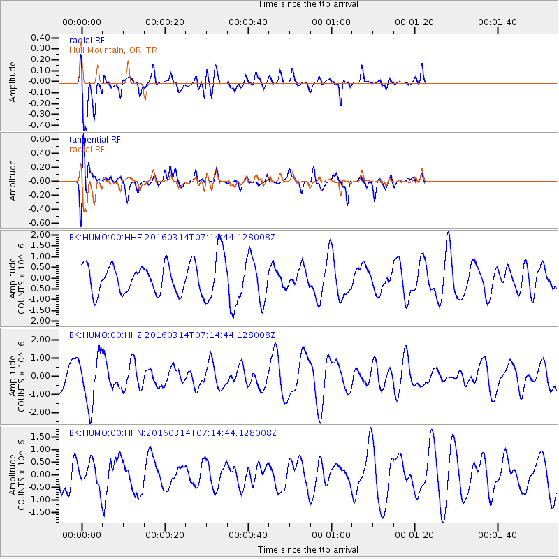
HUMO Hull Mountain, OR - Earthquake Result Viewer
*The percent match for this event was below the threshold and hence no stack was calculated.
| Earthquake location: |
Northwest Of Ryukyu Islands |
| Earthquake latitude/longitude: |
29.8/129.0 |
| Earthquake time(UTC): |
2016/03/14 (074) 07:03:17 GMT |
| Earthquake Depth: |
208 km |
| Earthquake Magnitude: |
5.5 MB |
| Earthquake Catalog/Contributor: |
NEIC PDE/NEIC COMCAT |
|
| Network: |
BK Berkeley Digital Seismograph Network |
| Station: |
HUMO Hull Mountain, OR |
| Lat/Lon: |
42.61 N/122.96 W |
| Elevation: |
555 m |
|
| Distance: |
82.2 deg |
| Az: |
45.104 deg |
| Baz: |
303.528 deg |
| Ray Param: |
$rayparam |
*The percent match for this event was below the threshold and hence was not used in the summary stack. |
|
| Radial Match: |
55.863167 % |
| Radial Bump: |
386 |
| Transverse Match: |
58.50347 % |
| Transverse Bump: |
400 |
| SOD ConfigId: |
1453031 |
| Insert Time: |
2016-03-28 07:22:19.273 +0000 |
| GWidth: |
2.5 |
| Max Bumps: |
400 |
| Tol: |
0.001 |
|
Signal To Noise
| Channel | StoN | STA | LTA |
| BK:HUMO:00:HHZ:20160314T07:14:44.128008Z | 2.1474273 | 1.3591607E-6 | 6.329251E-7 |
| BK:HUMO:00:HHN:20160314T07:14:44.128008Z | 0.75375366 | 4.7704754E-7 | 6.3289576E-7 |
| BK:HUMO:00:HHE:20160314T07:14:44.128008Z | 2.0672772 | 1.2359518E-6 | 5.978645E-7 |
| Arrivals |
| Ps | |
| PpPs | |
| PsPs/PpSs | |


