You are here: Home > Network List > US - United States National Seismic Network Stations List
> Station EGMT Eagleton, Montana, USA > Earthquake Result Viewer
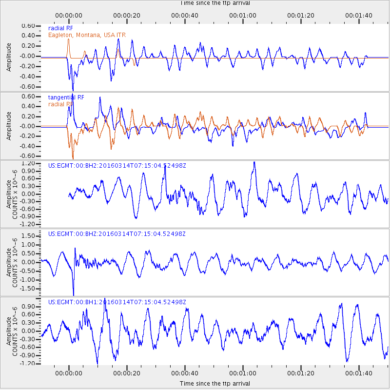
EGMT Eagleton, Montana, USA - Earthquake Result Viewer
*The percent match for this event was below the threshold and hence no stack was calculated.
| Earthquake location: |
Northwest Of Ryukyu Islands |
| Earthquake latitude/longitude: |
29.8/129.0 |
| Earthquake time(UTC): |
2016/03/14 (074) 07:03:17 GMT |
| Earthquake Depth: |
208 km |
| Earthquake Magnitude: |
5.5 MB |
| Earthquake Catalog/Contributor: |
NEIC PDE/NEIC COMCAT |
|
| Network: |
US United States National Seismic Network |
| Station: |
EGMT Eagleton, Montana, USA |
| Lat/Lon: |
48.02 N/109.75 W |
| Elevation: |
1055 m |
|
| Distance: |
86.3 deg |
| Az: |
35.1 deg |
| Baz: |
311.913 deg |
| Ray Param: |
$rayparam |
*The percent match for this event was below the threshold and hence was not used in the summary stack. |
|
| Radial Match: |
60.94247 % |
| Radial Bump: |
400 |
| Transverse Match: |
56.0415 % |
| Transverse Bump: |
400 |
| SOD ConfigId: |
1453031 |
| Insert Time: |
2016-03-28 07:33:16.074 +0000 |
| GWidth: |
2.5 |
| Max Bumps: |
400 |
| Tol: |
0.001 |
|
Signal To Noise
| Channel | StoN | STA | LTA |
| US:EGMT:00:BHZ:20160314T07:15:04.52498Z | 2.2522562 | 5.4529175E-7 | 2.421091E-7 |
| US:EGMT:00:BH1:20160314T07:15:04.52498Z | 0.66375434 | 2.4789398E-7 | 3.734725E-7 |
| US:EGMT:00:BH2:20160314T07:15:04.52498Z | 1.5208292 | 5.059364E-7 | 3.326714E-7 |
| Arrivals |
| Ps | |
| PpPs | |
| PsPs/PpSs | |


