You are here: Home > Network List > TA - USArray Transportable Network (new EarthScope stations) Stations List
> Station D25K Kavik River, AK, USA > Earthquake Result Viewer
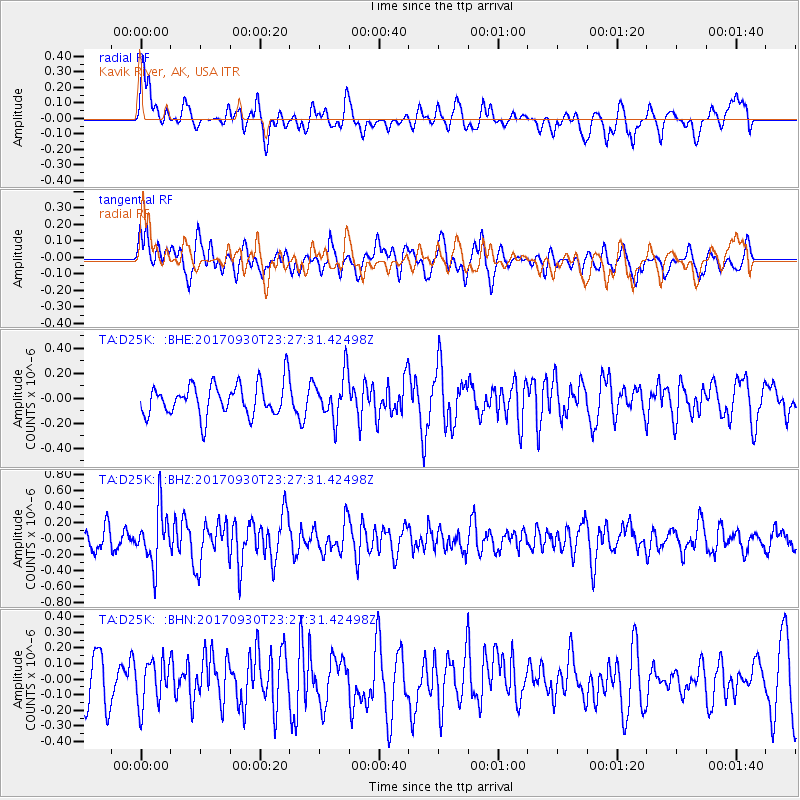
D25K Kavik River, AK, USA - Earthquake Result Viewer
*The percent match for this event was below the threshold and hence no stack was calculated.
| Earthquake location: |
North Of Halmahera, Indonesia |
| Earthquake latitude/longitude: |
3.9/128.5 |
| Earthquake time(UTC): |
2017/09/30 (273) 23:15:29 GMT |
| Earthquake Depth: |
10 km |
| Earthquake Magnitude: |
5.5 Mww |
| Earthquake Catalog/Contributor: |
NEIC PDE/us |
|
| Network: |
TA USArray Transportable Network (new EarthScope stations) |
| Station: |
D25K Kavik River, AK, USA |
| Lat/Lon: |
69.32 N/146.38 W |
| Elevation: |
770 m |
|
| Distance: |
84.6 deg |
| Az: |
20.822 deg |
| Baz: |
266.793 deg |
| Ray Param: |
$rayparam |
*The percent match for this event was below the threshold and hence was not used in the summary stack. |
|
| Radial Match: |
59.693214 % |
| Radial Bump: |
400 |
| Transverse Match: |
48.918743 % |
| Transverse Bump: |
400 |
| SOD ConfigId: |
13570011 |
| Insert Time: |
2019-04-28 22:04:54.600 +0000 |
| GWidth: |
2.5 |
| Max Bumps: |
400 |
| Tol: |
0.001 |
|
Signal To Noise
| Channel | StoN | STA | LTA |
| TA:D25K: :BHZ:20170930T23:27:31.42498Z | 2.0329678 | 3.3999606E-7 | 1.6724125E-7 |
| TA:D25K: :BHN:20170930T23:27:31.42498Z | 0.82394683 | 1.4281268E-7 | 1.7332755E-7 |
| TA:D25K: :BHE:20170930T23:27:31.42498Z | 1.372811 | 1.7684276E-7 | 1.2881799E-7 |
| Arrivals |
| Ps | |
| PpPs | |
| PsPs/PpSs | |


