You are here: Home > Network List > TA - USArray Transportable Network (new EarthScope stations) Stations List
> Station L15K Ungalak Mountain, AK, USA > Earthquake Result Viewer
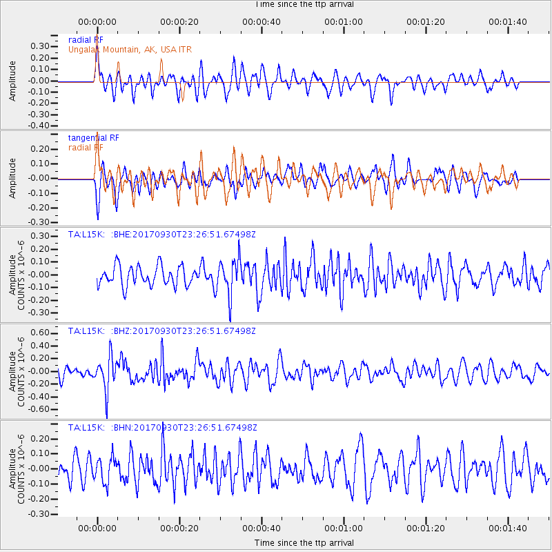
L15K Ungalak Mountain, AK, USA - Earthquake Result Viewer
*The percent match for this event was below the threshold and hence no stack was calculated.
| Earthquake location: |
North Of Halmahera, Indonesia |
| Earthquake latitude/longitude: |
3.9/128.5 |
| Earthquake time(UTC): |
2017/09/30 (273) 23:15:29 GMT |
| Earthquake Depth: |
10 km |
| Earthquake Magnitude: |
5.5 Mww |
| Earthquake Catalog/Contributor: |
NEIC PDE/us |
|
| Network: |
TA USArray Transportable Network (new EarthScope stations) |
| Station: |
L15K Ungalak Mountain, AK, USA |
| Lat/Lon: |
61.68 N/161.49 W |
| Elevation: |
219 m |
|
| Distance: |
77.1 deg |
| Az: |
27.363 deg |
| Baz: |
254.056 deg |
| Ray Param: |
$rayparam |
*The percent match for this event was below the threshold and hence was not used in the summary stack. |
|
| Radial Match: |
58.28585 % |
| Radial Bump: |
400 |
| Transverse Match: |
52.31965 % |
| Transverse Bump: |
400 |
| SOD ConfigId: |
13570011 |
| Insert Time: |
2019-04-28 22:05:38.204 +0000 |
| GWidth: |
2.5 |
| Max Bumps: |
400 |
| Tol: |
0.001 |
|
Signal To Noise
| Channel | StoN | STA | LTA |
| TA:L15K: :BHZ:20170930T23:26:51.67498Z | 2.9162142 | 2.6725533E-7 | 9.1644615E-8 |
| TA:L15K: :BHN:20170930T23:26:51.67498Z | 1.1038835 | 8.265026E-8 | 7.4872275E-8 |
| TA:L15K: :BHE:20170930T23:26:51.67498Z | 1.9213586 | 1.4321111E-7 | 7.453638E-8 |
| Arrivals |
| Ps | |
| PpPs | |
| PsPs/PpSs | |


