You are here: Home > Network List > UU - University of Utah Regional Network Stations List
> Station KNB Kanab, UT, USA > Earthquake Result Viewer
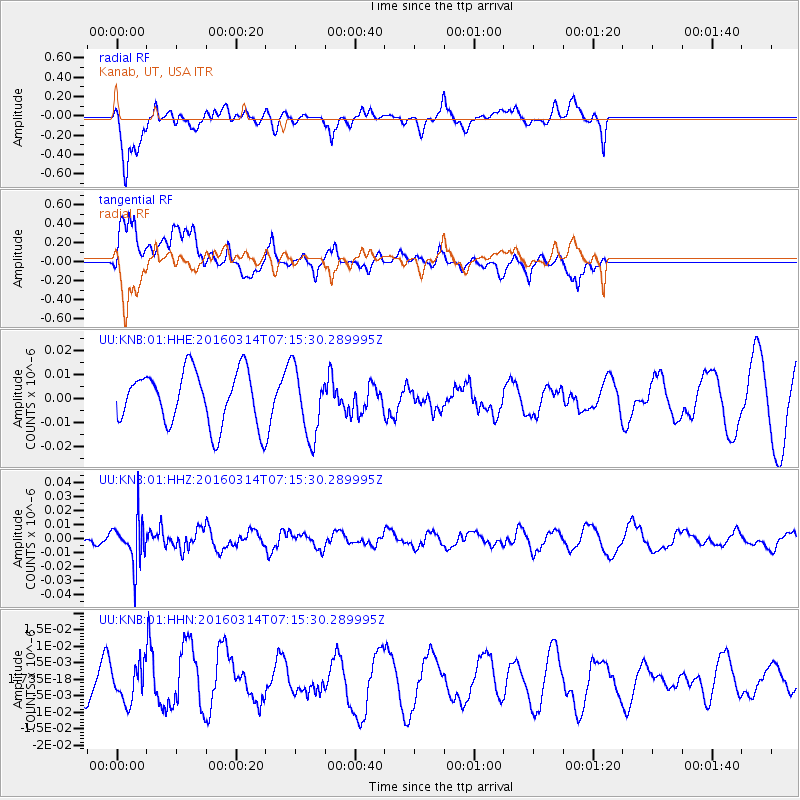
KNB Kanab, UT, USA - Earthquake Result Viewer
*The percent match for this event was below the threshold and hence no stack was calculated.
| Earthquake location: |
Northwest Of Ryukyu Islands |
| Earthquake latitude/longitude: |
29.8/129.0 |
| Earthquake time(UTC): |
2016/03/14 (074) 07:03:17 GMT |
| Earthquake Depth: |
208 km |
| Earthquake Magnitude: |
5.5 MB |
| Earthquake Catalog/Contributor: |
NEIC PDE/NEIC COMCAT |
|
| Network: |
UU University of Utah Regional Network |
| Station: |
KNB Kanab, UT, USA |
| Lat/Lon: |
37.02 N/112.82 W |
| Elevation: |
1715 m |
|
| Distance: |
91.8 deg |
| Az: |
44.892 deg |
| Baz: |
309.998 deg |
| Ray Param: |
$rayparam |
*The percent match for this event was below the threshold and hence was not used in the summary stack. |
|
| Radial Match: |
46.33878 % |
| Radial Bump: |
400 |
| Transverse Match: |
75.481316 % |
| Transverse Bump: |
400 |
| SOD ConfigId: |
1453031 |
| Insert Time: |
2016-03-28 07:34:55.909 +0000 |
| GWidth: |
2.5 |
| Max Bumps: |
400 |
| Tol: |
0.001 |
|
Signal To Noise
| Channel | StoN | STA | LTA |
| UU:KNB:01:HHZ:20160314T07:15:30.289995Z | 2.5410962 | 1.6026238E-8 | 6.306821E-9 |
| UU:KNB:01:HHN:20160314T07:15:30.289995Z | 0.5905057 | 5.4992273E-9 | 9.312743E-9 |
| UU:KNB:01:HHE:20160314T07:15:30.289995Z | 1.2923703 | 1.4261421E-8 | 1.1035088E-8 |
| Arrivals |
| Ps | |
| PpPs | |
| PsPs/PpSs | |


