You are here: Home > Network List > UU - University of Utah Regional Network Stations List
> Station FORU South Mineral Mountains, UT, USA > Earthquake Result Viewer
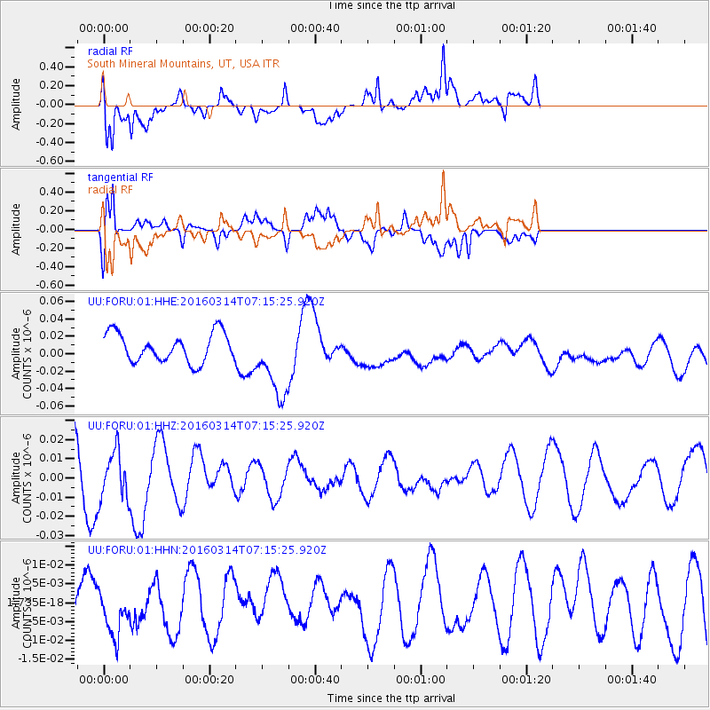
FORU South Mineral Mountains, UT, USA - Earthquake Result Viewer
*The percent match for this event was below the threshold and hence no stack was calculated.
| Earthquake location: |
Northwest Of Ryukyu Islands |
| Earthquake latitude/longitude: |
29.8/129.0 |
| Earthquake time(UTC): |
2016/03/14 (074) 07:03:17 GMT |
| Earthquake Depth: |
208 km |
| Earthquake Magnitude: |
5.5 MB |
| Earthquake Catalog/Contributor: |
NEIC PDE/NEIC COMCAT |
|
| Network: |
UU University of Utah Regional Network |
| Station: |
FORU South Mineral Mountains, UT, USA |
| Lat/Lon: |
38.46 N/112.86 W |
| Elevation: |
1840 m |
|
| Distance: |
90.9 deg |
| Az: |
43.809 deg |
| Baz: |
309.999 deg |
| Ray Param: |
$rayparam |
*The percent match for this event was below the threshold and hence was not used in the summary stack. |
|
| Radial Match: |
58.127415 % |
| Radial Bump: |
400 |
| Transverse Match: |
54.73574 % |
| Transverse Bump: |
400 |
| SOD ConfigId: |
1453031 |
| Insert Time: |
2016-03-28 07:36:36.493 +0000 |
| GWidth: |
2.5 |
| Max Bumps: |
400 |
| Tol: |
0.001 |
|
Signal To Noise
| Channel | StoN | STA | LTA |
| UU:FORU:01:HHZ:20160314T07:15:25.920Z | 0.87207097 | 1.22894965E-8 | 1.4092313E-8 |
| UU:FORU:01:HHN:20160314T07:15:25.920Z | 0.6645372 | 6.088686E-9 | 9.162296E-9 |
| UU:FORU:01:HHE:20160314T07:15:25.920Z | 2.600164 | 4.2687756E-8 | 1.6417333E-8 |
| Arrivals |
| Ps | |
| PpPs | |
| PsPs/PpSs | |


