You are here: Home > Network List > TA - USArray Transportable Network (new EarthScope stations) Stations List
> Station F15A Butte, MT, USA > Earthquake Result Viewer
F15A Butte, MT, USA - Earthquake Result Viewer
| Earthquake location: |
Off Coast Of Ecuador |
| Earthquake latitude/longitude: |
1.4/-85.2 |
| Earthquake time(UTC): |
2009/05/10 (130) 01:16:06 GMT |
| Earthquake Depth: |
6.0 km |
| Earthquake Magnitude: |
5.5 MB, 5.7 MS, 6.1 MW, 6.1 MW |
| Earthquake Catalog/Contributor: |
WHDF/NEIC |
|
| Network: |
TA USArray Transportable Network (new EarthScope stations) |
| Station: |
F15A Butte, MT, USA |
| Lat/Lon: |
45.84 N/112.49 W |
| Elevation: |
1995 m |
|
| Distance: |
50.3 deg |
| Az: |
335.369 deg |
| Baz: |
143.414 deg |
| Ray Param: |
0.06812959 |
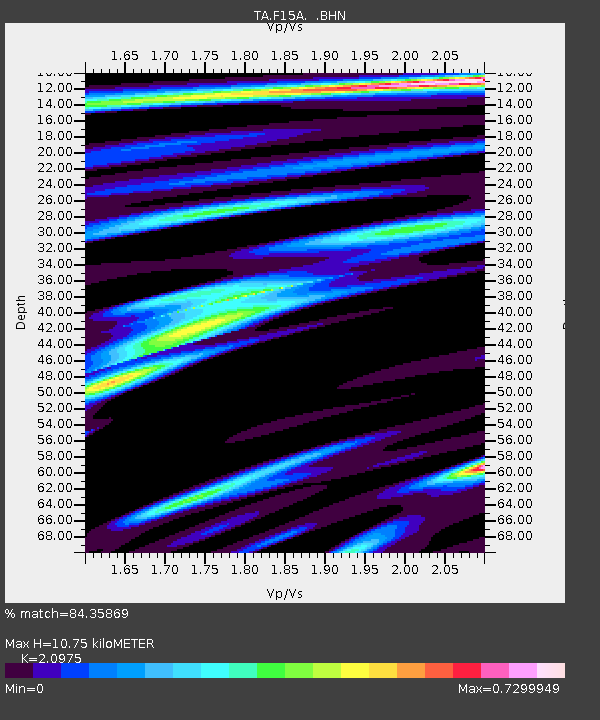
| Estimated Moho Depth: |
10.75 km |
| Estimated Crust Vp/Vs: |
2.10 |
| Assumed Crust Vp: |
6.577 km/s |
| Estimated Crust Vs: |
3.136 km/s |
| Estimated Crust Poisson's Ratio: |
0.35 |
|
| Radial Match: |
84.35869 % |
| Radial Bump: |
260 |
| Transverse Match: |
66.27111 % |
| Transverse Bump: |
371 |
| SOD ConfigId: |
2760 |
| Insert Time: |
2010-03-06 04:53:43.358 +0000 |
| GWidth: |
2.5 |
| Max Bumps: |
400 |
| Tol: |
0.001 |
|
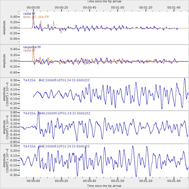
Signal To Noise
| Channel | StoN | STA | LTA |
| TA:F15A: :BHN:20090510T01:24:33.600015Z | 4.8857393 | 3.604961E-7 | 7.378538E-8 |
| TA:F15A: :BHE:20090510T01:24:33.600015Z | 3.064499 | 1.3384512E-7 | 4.367602E-8 |
| TA:F15A: :BHZ:20090510T01:24:33.600015Z | 1.624534 | 7.406987E-8 | 4.5594533E-8 |
| Arrivals |
| Ps | 1.9 SECOND |
| PpPs | 4.8 SECOND |
| PsPs/PpSs | 6.7 SECOND |


