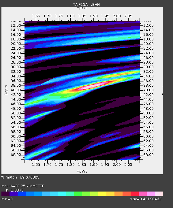
F15A Butte, MT, USA - Earthquake Result Viewer

Earthquake location: Andreanof Islands, Aleutian Is.
Earthquake latitude/longitude: 51.9/-179.4
Earthquake time(UTC): 2008/04/15 (106) 22:59:51 GMT
Earthquake Depth: 10 km
Earthquake Magnitude: 6.1 MB, 6.4 MS, 6.4 MW, 6.4 MW
Earthquake Catalog/Contributor: WHDF/NEIC
Network: TA USArray Transportable Network (new EarthScope stations)
Station: F15A Butte, MT, USA
Lat/Lon: 45.84 N/112.49 W
Elevation: 1995 m
Distance: 43.0 deg
Az: 70.467 deg
Baz: 303.261 deg
Ray Param: 0.07282762
Estimated Moho Depth: 38.25 km
Estimated Crust Vp/Vs: 1.89
Assumed Crust Vp: 6.577 km/s
Estimated Crust Vs: 3.484 km/s
Estimated Crust Poisson's Ratio: 0.30
Radial Match: 89.076805 %
Radial Bump: 272
Transverse Match: 76.02493 %
Transverse Bump: 400
SOD ConfigId: 2504
Insert Time: 2010-03-06 04:53:49.410 +0000
GWidth: 2.5
Max Bumps: 400
Tol: 0.001

Signal To Noise

ChannelStoNSTALTA
TA:F15A: :BHN:20080415T23:07:19.950006Z3.82093056.1712325E-71.6151124E-7
TA:F15A: :BHE:20080415T23:07:19.950006Z2.83532712.9740664E-71.0489324E-7
TA:F15A: :BHZ:20080415T23:07:19.950006Z2.26725772.7263323E-71.2024802E-7
Arrivals
Ps5.5 SECOND
PpPs16 SECOND
PsPs/PpSs21 SECOND