You are here: Home > Network List > TA - USArray Transportable Network (new EarthScope stations) Stations List
> Station F15A Butte, MT, USA > Earthquake Result Viewer
F15A Butte, MT, USA - Earthquake Result Viewer
| Earthquake location: |
Iceland |
| Earthquake latitude/longitude: |
64.0/-21.0 |
| Earthquake time(UTC): |
2008/05/29 (150) 15:46:00 GMT |
| Earthquake Depth: |
10 km |
| Earthquake Magnitude: |
6.0 MB, 6.2 MS, 6.3 MW, 6.2 MW |
| Earthquake Catalog/Contributor: |
WHDF/NEIC |
|
| Network: |
TA USArray Transportable Network (new EarthScope stations) |
| Station: |
F15A Butte, MT, USA |
| Lat/Lon: |
45.84 N/112.49 W |
| Elevation: |
1995 m |
|
| Distance: |
50.7 deg |
| Az: |
295.367 deg |
| Baz: |
34.724 deg |
| Ray Param: |
0.067907415 |
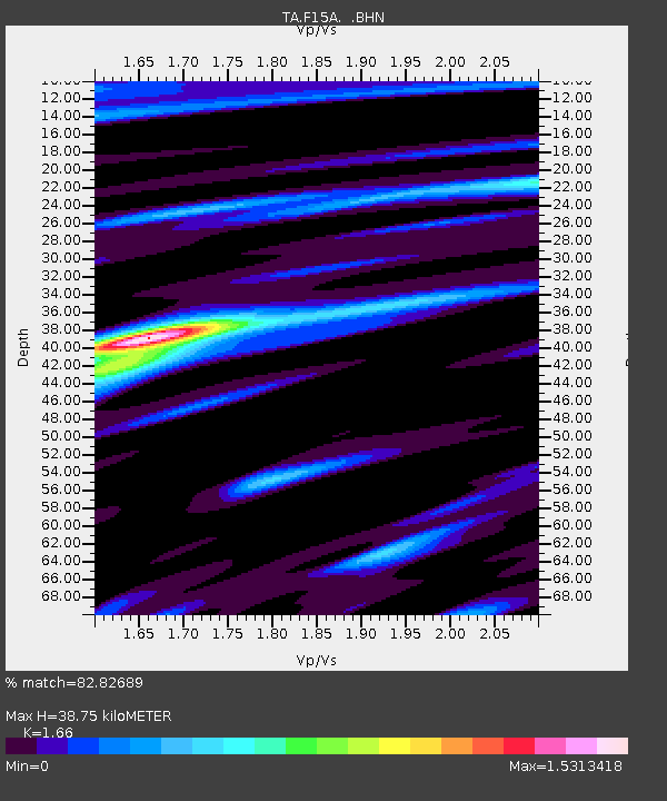
| Estimated Moho Depth: |
38.75 km |
| Estimated Crust Vp/Vs: |
1.66 |
| Assumed Crust Vp: |
6.577 km/s |
| Estimated Crust Vs: |
3.962 km/s |
| Estimated Crust Poisson's Ratio: |
0.22 |
|
| Radial Match: |
82.82689 % |
| Radial Bump: |
367 |
| Transverse Match: |
68.62754 % |
| Transverse Bump: |
400 |
| SOD ConfigId: |
2504 |
| Insert Time: |
2010-03-06 04:54:09.488 +0000 |
| GWidth: |
2.5 |
| Max Bumps: |
400 |
| Tol: |
0.001 |
|

Signal To Noise
| Channel | StoN | STA | LTA |
| TA:F15A: :BHN:20080529T15:54:28.850005Z | 6.494274 | 5.4623854E-7 | 8.411079E-8 |
| TA:F15A: :BHE:20080529T15:54:28.850005Z | 4.408646 | 2.7774144E-7 | 6.2999256E-8 |
| TA:F15A: :BHZ:20080529T15:54:28.850005Z | 2.7370517 | 1.4622233E-7 | 5.3423303E-8 |
| Arrivals |
| Ps | 4.1 SECOND |
| PpPs | 15 SECOND |
| PsPs/PpSs | 19 SECOND |


