You are here: Home > Network List > GT - Global Telemetered Seismograph Network (USAF/USGS) Stations List
> Station LPAZ La Paz , Bolivia > Earthquake Result Viewer
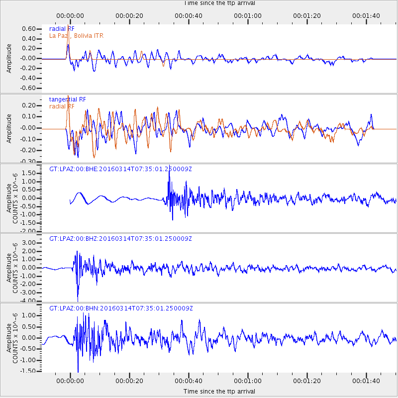
LPAZ La Paz , Bolivia - Earthquake Result Viewer
*The percent match for this event was below the threshold and hence no stack was calculated.
| Earthquake location: |
South Sandwich Islands Region |
| Earthquake latitude/longitude: |
-56.4/-27.1 |
| Earthquake time(UTC): |
2016/03/14 (074) 07:26:43 GMT |
| Earthquake Depth: |
104 km |
| Earthquake Magnitude: |
5.7 MB |
| Earthquake Catalog/Contributor: |
NEIC PDE/NEIC COMCAT |
|
| Network: |
GT Global Telemetered Seismograph Network (USAF/USGS) |
| Station: |
LPAZ La Paz , Bolivia |
| Lat/Lon: |
16.17 S/68.08 W |
| Elevation: |
4817 m |
|
| Distance: |
50.7 deg |
| Az: |
305.499 deg |
| Baz: |
151.93 deg |
| Ray Param: |
$rayparam |
*The percent match for this event was below the threshold and hence was not used in the summary stack. |
|
| Radial Match: |
74.909004 % |
| Radial Bump: |
400 |
| Transverse Match: |
58.906525 % |
| Transverse Bump: |
400 |
| SOD ConfigId: |
1453031 |
| Insert Time: |
2016-03-28 07:42:45.152 +0000 |
| GWidth: |
2.5 |
| Max Bumps: |
400 |
| Tol: |
0.001 |
|
Signal To Noise
| Channel | StoN | STA | LTA |
| GT:LPAZ:00:BHZ:20160314T07:35:01.250009Z | 10.192701 | 1.1397964E-6 | 1.11824754E-7 |
| GT:LPAZ:00:BHN:20160314T07:35:01.250009Z | 3.1701784 | 4.6009384E-7 | 1.4513185E-7 |
| GT:LPAZ:00:BHE:20160314T07:35:01.250009Z | 3.2319584 | 5.0135816E-7 | 1.5512518E-7 |
| Arrivals |
| Ps | |
| PpPs | |
| PsPs/PpSs | |


