You are here: Home > Network List > TA - USArray Transportable Network (new EarthScope stations) Stations List
> Station C16K Lisburne Hills, AK, USA > Earthquake Result Viewer
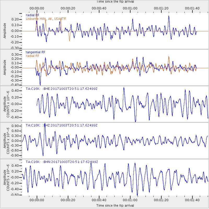
C16K Lisburne Hills, AK, USA - Earthquake Result Viewer
*The percent match for this event was below the threshold and hence no stack was calculated.
| Earthquake location: |
North Atlantic Ocean |
| Earthquake latitude/longitude: |
13.5/-49.3 |
| Earthquake time(UTC): |
2017/10/03 (276) 20:39:04 GMT |
| Earthquake Depth: |
10 km |
| Earthquake Magnitude: |
5.7 Mww |
| Earthquake Catalog/Contributor: |
NEIC PDE/us |
|
| Network: |
TA USArray Transportable Network (new EarthScope stations) |
| Station: |
C16K Lisburne Hills, AK, USA |
| Lat/Lon: |
68.27 N/165.34 W |
| Elevation: |
102 m |
|
| Distance: |
86.8 deg |
| Az: |
340.423 deg |
| Baz: |
61.118 deg |
| Ray Param: |
$rayparam |
*The percent match for this event was below the threshold and hence was not used in the summary stack. |
|
| Radial Match: |
54.08723 % |
| Radial Bump: |
400 |
| Transverse Match: |
51.182404 % |
| Transverse Bump: |
400 |
| SOD ConfigId: |
13570011 |
| Insert Time: |
2019-04-28 22:13:27.833 +0000 |
| GWidth: |
2.5 |
| Max Bumps: |
400 |
| Tol: |
0.001 |
|
Signal To Noise
| Channel | StoN | STA | LTA |
| TA:C16K: :BHZ:20171003T20:51:17.62499Z | 1.952626 | 4.017052E-7 | 2.0572561E-7 |
| TA:C16K: :BHN:20171003T20:51:17.62499Z | 0.49383807 | 1.2564803E-7 | 2.5443165E-7 |
| TA:C16K: :BHE:20171003T20:51:17.62499Z | 0.45893255 | 8.082357E-8 | 1.7611208E-7 |
| Arrivals |
| Ps | |
| PpPs | |
| PsPs/PpSs | |


