You are here: Home > Network List > CI - Caltech Regional Seismic Network Stations List
> Station SMM Simmler, CA, USA > Earthquake Result Viewer
SMM Simmler, CA, USA - Earthquake Result Viewer
| Earthquake location: |
Kermadec Islands, New Zealand |
| Earthquake latitude/longitude: |
-29.8/-177.7 |
| Earthquake time(UTC): |
2008/09/29 (273) 15:19:31 GMT |
| Earthquake Depth: |
36 km |
| Earthquake Magnitude: |
6.5 MB, 6.7 MS, 7.0 MW, 7.0 MW |
| Earthquake Catalog/Contributor: |
WHDF/NEIC |
|
| Network: |
CI Caltech Regional Seismic Network |
| Station: |
SMM Simmler, CA, USA |
| Lat/Lon: |
35.31 N/120.00 W |
| Elevation: |
599 m |
|
| Distance: |
84.5 deg |
| Az: |
43.978 deg |
| Baz: |
227.589 deg |
| Ray Param: |
0.045393445 |
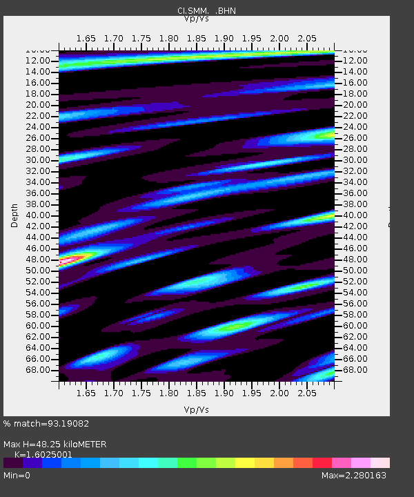
| Estimated Moho Depth: |
48.25 km |
| Estimated Crust Vp/Vs: |
1.60 |
| Assumed Crust Vp: |
6.1 km/s |
| Estimated Crust Vs: |
3.807 km/s |
| Estimated Crust Poisson's Ratio: |
0.18 |
|
| Radial Match: |
93.19082 % |
| Radial Bump: |
400 |
| Transverse Match: |
89.179375 % |
| Transverse Bump: |
400 |
| SOD ConfigId: |
2560 |
| Insert Time: |
2010-02-26 01:30:35.051 +0000 |
| GWidth: |
2.5 |
| Max Bumps: |
400 |
| Tol: |
0.001 |
|
Signal To Noise
| Channel | StoN | STA | LTA |
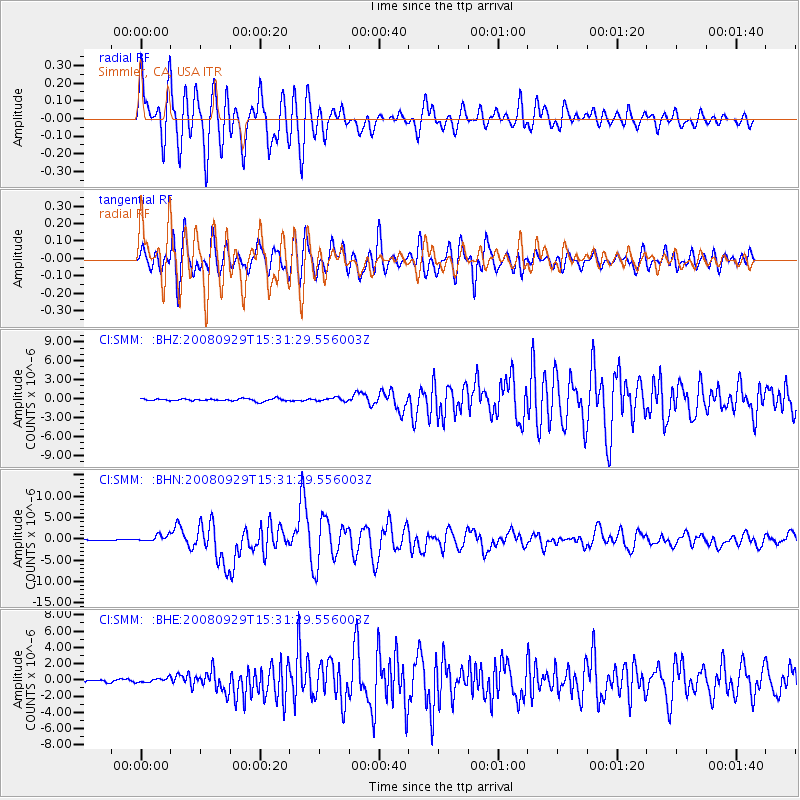
| CI:SMM: :BHN:20080929T15:31:29.556003Z | 5.022896 | 8.3182346E-7 | 1.6560635E-7 |
| CI:SMM: :BHE:20080929T15:31:29.556003Z | 1.7212446 | 2.8836942E-7 | 1.6753542E-7 |
| CI:SMM: :BHZ:20080929T15:31:29.556003Z | 1.3163452 | 2.5434503E-7 | 1.9322063E-7 |
| Arrivals |
| Ps | 4.9 SECOND |
| PpPs | 20 SECOND |
| PsPs/PpSs | 25 SECOND |


