You are here: Home > Network List > TA - USArray Transportable Network (new EarthScope stations) Stations List
> Station MDND Maddock, ND, USA > Earthquake Result Viewer
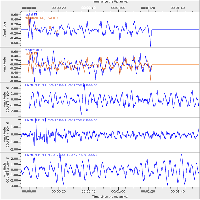
MDND Maddock, ND, USA - Earthquake Result Viewer
*The percent match for this event was below the threshold and hence no stack was calculated.
| Earthquake location: |
North Atlantic Ocean |
| Earthquake latitude/longitude: |
13.5/-49.3 |
| Earthquake time(UTC): |
2017/10/03 (276) 20:39:04 GMT |
| Earthquake Depth: |
10 km |
| Earthquake Magnitude: |
5.7 Mww |
| Earthquake Catalog/Contributor: |
NEIC PDE/us |
|
| Network: |
TA USArray Transportable Network (new EarthScope stations) |
| Station: |
MDND Maddock, ND, USA |
| Lat/Lon: |
47.85 N/99.60 W |
| Elevation: |
479 m |
|
| Distance: |
53.9 deg |
| Az: |
320.096 deg |
| Baz: |
112.092 deg |
| Ray Param: |
$rayparam |
*The percent match for this event was below the threshold and hence was not used in the summary stack. |
|
| Radial Match: |
47.624325 % |
| Radial Bump: |
400 |
| Transverse Match: |
56.62269 % |
| Transverse Bump: |
341 |
| SOD ConfigId: |
13570011 |
| Insert Time: |
2019-04-28 22:13:51.328 +0000 |
| GWidth: |
2.5 |
| Max Bumps: |
400 |
| Tol: |
0.001 |
|
Signal To Noise
| Channel | StoN | STA | LTA |
| TA:MDND: :HHZ:20171003T20:47:56.830007Z | 3.5211706 | 8.058747E-7 | 2.2886557E-7 |
| TA:MDND: :HHN:20171003T20:47:56.830007Z | 2.2588563 | 1.1815255E-6 | 5.230636E-7 |
| TA:MDND: :HHE:20171003T20:47:56.830007Z | 1.0431113 | 8.20213E-7 | 7.86314E-7 |
| Arrivals |
| Ps | |
| PpPs | |
| PsPs/PpSs | |


