You are here: Home > Network List > TA - USArray Transportable Network (new EarthScope stations) Stations List
> Station WHTX Lake Whitney, Meridian, TX, USA > Earthquake Result Viewer
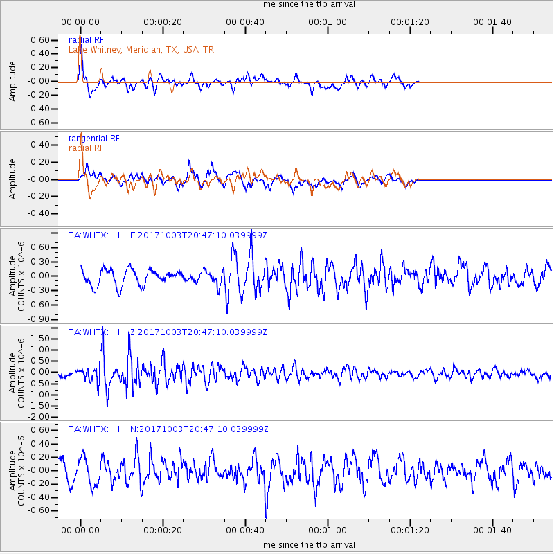
WHTX Lake Whitney, Meridian, TX, USA - Earthquake Result Viewer
*The percent match for this event was below the threshold and hence no stack was calculated.
| Earthquake location: |
North Atlantic Ocean |
| Earthquake latitude/longitude: |
13.5/-49.3 |
| Earthquake time(UTC): |
2017/10/03 (276) 20:39:04 GMT |
| Earthquake Depth: |
10 km |
| Earthquake Magnitude: |
5.7 Mww |
| Earthquake Catalog/Contributor: |
NEIC PDE/us |
|
| Network: |
TA USArray Transportable Network (new EarthScope stations) |
| Station: |
WHTX Lake Whitney, Meridian, TX, USA |
| Lat/Lon: |
31.99 N/97.46 W |
| Elevation: |
190 m |
|
| Distance: |
47.7 deg |
| Az: |
301.106 deg |
| Baz: |
101.381 deg |
| Ray Param: |
$rayparam |
*The percent match for this event was below the threshold and hence was not used in the summary stack. |
|
| Radial Match: |
65.24728 % |
| Radial Bump: |
400 |
| Transverse Match: |
72.37234 % |
| Transverse Bump: |
400 |
| SOD ConfigId: |
13570011 |
| Insert Time: |
2019-04-28 22:14:05.407 +0000 |
| GWidth: |
2.5 |
| Max Bumps: |
400 |
| Tol: |
0.001 |
|
Signal To Noise
| Channel | StoN | STA | LTA |
| TA:WHTX: :HHZ:20171003T20:47:10.039999Z | 1.7303283 | 3.5223056E-7 | 2.0356285E-7 |
| TA:WHTX: :HHN:20171003T20:47:10.039999Z | 1.4468889 | 1.9767842E-7 | 1.3662307E-7 |
| TA:WHTX: :HHE:20171003T20:47:10.039999Z | 0.917574 | 1.4747403E-7 | 1.6072167E-7 |
| Arrivals |
| Ps | |
| PpPs | |
| PsPs/PpSs | |


