You are here: Home > Network List > CI - Caltech Regional Seismic Network Stations List
> Station SMM Simmler, CA, USA > Earthquake Result Viewer
SMM Simmler, CA, USA - Earthquake Result Viewer
| Earthquake location: |
East Of Kuril Islands |
| Earthquake latitude/longitude: |
46.9/155.2 |
| Earthquake time(UTC): |
2009/01/15 (015) 17:49:39 GMT |
| Earthquake Depth: |
36 km |
| Earthquake Magnitude: |
6.9 MB, 7.5 MS, 7.4 MW, 7.4 MW |
| Earthquake Catalog/Contributor: |
WHDF/NEIC |
|
| Network: |
CI Caltech Regional Seismic Network |
| Station: |
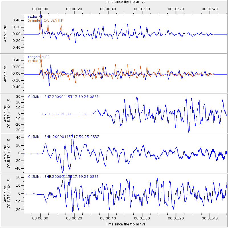
SMM Simmler, CA, USA |
| Lat/Lon: |
35.31 N/120.00 W |
| Elevation: |
599 m |
|
| Distance: |
62.0 deg |
| Az: |
67.251 deg |
| Baz: |
309.298 deg |
| Ray Param: |
0.060429595 |
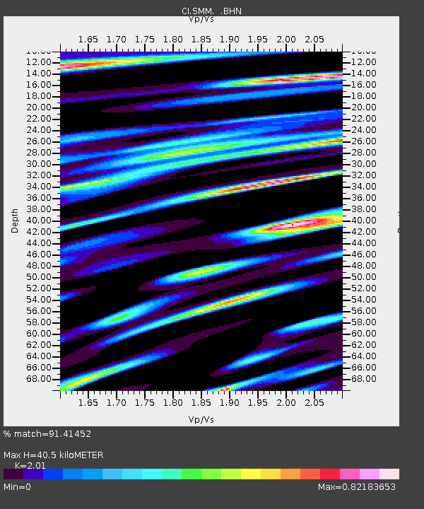
| Estimated Moho Depth: |
40.5 km |
| Estimated Crust Vp/Vs: |
2.01 |
| Assumed Crust Vp: |
6.1 km/s |
| Estimated Crust Vs: |
3.035 km/s |
| Estimated Crust Poisson's Ratio: |
0.34 |
|
| Radial Match: |
91.41452 % |
| Radial Bump: |
400 |
| Transverse Match: |
86.27684 % |
| Transverse Bump: |
400 |
| SOD ConfigId: |
2834 |
| Insert Time: |
2010-02-26 01:30:37.358 +0000 |
| GWidth: |
2.5 |
| Max Bumps: |
400 |
| Tol: |
0.001 |
|
Signal To Noise
| Channel | StoN | STA | LTA |
| CI:SMM: :BHN:20090115T17:59:25.083Z | 37.37162 | 1.1711433E-5 | 3.1337774E-7 |
| CI:SMM: :BHE:20090115T17:59:25.083Z | 22.242239 | 4.4233507E-6 | 1.9887165E-7 |
| CI:SMM: :BHZ:20090115T17:59:25.083Z | 16.110878 | 3.983434E-6 | 2.472512E-7 |
| Arrivals |
| Ps | 6.9 SECOND |
| PpPs | 19 SECOND |
| PsPs/PpSs | 26 SECOND |


