You are here: Home > Network List > TA - USArray Transportable Network (new EarthScope stations) Stations List
> Station F15A Butte, MT, USA > Earthquake Result Viewer
F15A Butte, MT, USA - Earthquake Result Viewer

| Earthquake location: |
Peru-Ecuador Border Region |
| Earthquake latitude/longitude: |
-2.3/-77.8 |
| Earthquake time(UTC): |
2007/11/16 (320) 03:13:00 GMT |
| Earthquake Depth: |
123 km |
| Earthquake Magnitude: |
6.3 MB, 6.8 MW, 6.7 MW |
| Earthquake Catalog/Contributor: |
WHDF/NEIC |
|
| Network: |
TA USArray Transportable Network (new EarthScope stations) |
| Station: |
F15A Butte, MT, USA |
| Lat/Lon: |
45.84 N/112.49 W |
| Elevation: |
1995 m |
|
| Distance: |
56.9 deg |
| Az: |
331.677 deg |
| Baz: |
137.301 deg |
| Ray Param: |
0.06345567 |
| Estimated Moho Depth: |
25.5 km |
| Estimated Crust Vp/Vs: |
1.60 |
| Assumed Crust Vp: |
6.577 km/s |
| Estimated Crust Vs: |
4.104 km/s |
| Estimated Crust Poisson's Ratio: |
0.18 |
|
| Radial Match: |
94.56399 % |
| Radial Bump: |
400 |
| Transverse Match: |
73.24602 % |
| Transverse Bump: |
400 |
| SOD ConfigId: |
2564 |
| Insert Time: |
2010-03-06 04:55:47.018 +0000 |
| GWidth: |
2.5 |
| Max Bumps: |
400 |
| Tol: |
0.001 |
|
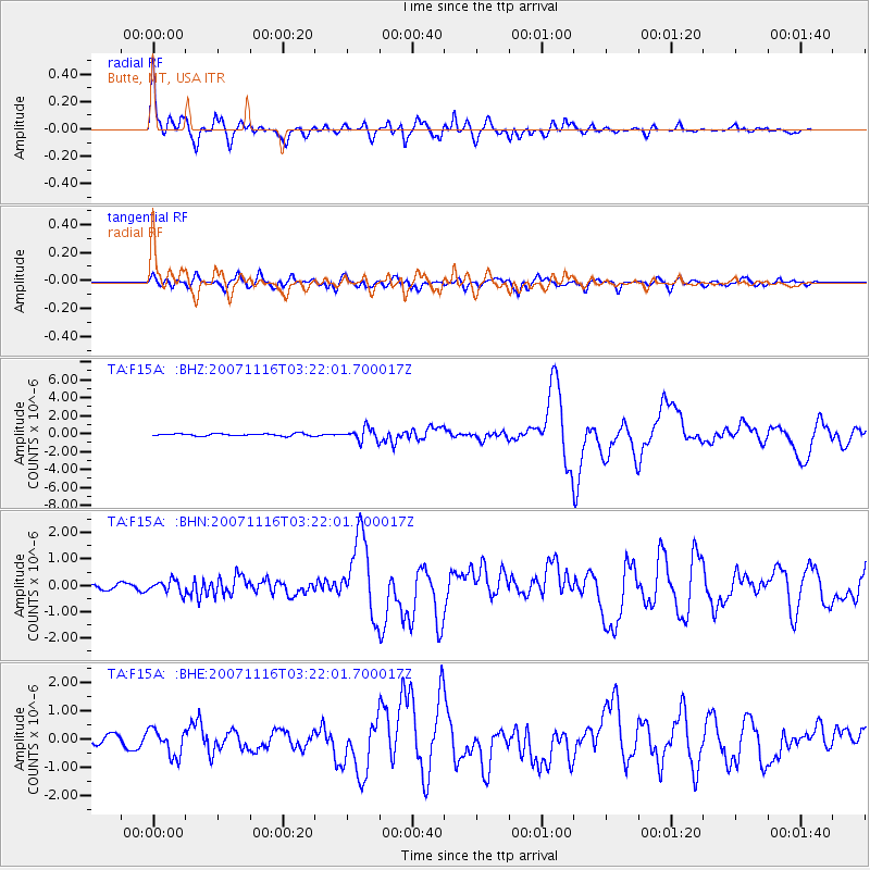
Signal To Noise
| Channel | StoN | STA | LTA |
| TA:F15A: :BHN:20071116T03:22:01.700017Z | 1.8193231 | 2.4188628E-7 | 1.32954E-7 |
| TA:F15A: :BHE:20071116T03:22:01.700017Z | 3.202823 | 4.7463536E-7 | 1.4819281E-7 |
| TA:F15A: :BHZ:20071116T03:22:01.700017Z | 5.381858 | 7.0571747E-7 | 1.3112897E-7 |
| Arrivals |
| Ps | 2.5 SECOND |
| PpPs | 9.5 SECOND |
| PsPs/PpSs | 12 SECOND |


