You are here: Home > Network List > II - Global Seismograph Network (GSN - IRIS/IDA) Stations List
> Station ABPO Ambohimpanompo, Madagascar > Earthquake Result Viewer
ABPO Ambohimpanompo, Madagascar - Earthquake Result Viewer

| Earthquake location: |
Southwest Of Africa |
| Earthquake latitude/longitude: |
-52.6/18.9 |
| Earthquake time(UTC): |
2016/03/14 (074) 23:25:40 GMT |
| Earthquake Depth: |
10 km |
| Earthquake Magnitude: |
5.8 MWP |
| Earthquake Catalog/Contributor: |
NEIC PDE/NEIC COMCAT |
|
| Network: |
II Global Seismograph Network (GSN - IRIS/IDA) |
| Station: |
ABPO Ambohimpanompo, Madagascar |
| Lat/Lon: |
19.02 S/47.23 E |
| Elevation: |
1528 m |
|
| Distance: |
40.2 deg |
| Az: |
44.181 deg |
| Baz: |
206.673 deg |
| Ray Param: |
0.074544795 |
| Estimated Moho Depth: |
33.75 km |
| Estimated Crust Vp/Vs: |
1.95 |
| Assumed Crust Vp: |
6.642 km/s |
| Estimated Crust Vs: |
3.406 km/s |
| Estimated Crust Poisson's Ratio: |
0.32 |
|
| Radial Match: |
87.81279 % |
| Radial Bump: |
282 |
| Transverse Match: |
55.028 % |
| Transverse Bump: |
400 |
| SOD ConfigId: |
1453031 |
| Insert Time: |
2016-03-28 23:40:26.891 +0000 |
| GWidth: |
2.5 |
| Max Bumps: |
400 |
| Tol: |
0.001 |
|
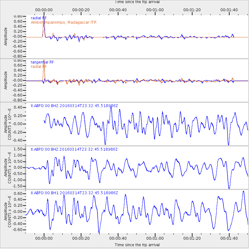
Signal To Noise
| Channel | StoN | STA | LTA |
| II:ABPO:00:BHZ:20160314T23:32:45.518986Z | 6.03755 | 5.413497E-7 | 8.96638E-8 |
| II:ABPO:00:BH1:20160314T23:32:45.518986Z | 2.642197 | 2.9504213E-7 | 1.11665464E-7 |
| II:ABPO:00:BH2:20160314T23:32:45.518986Z | 1.3831166 | 2.0586772E-7 | 1.4884336E-7 |
| Arrivals |
| Ps | 5.2 SECOND |
| PpPs | 14 SECOND |
| PsPs/PpSs | 19 SECOND |


