You are here: Home > Network List > TA - USArray Transportable Network (new EarthScope stations) Stations List
> Station F15A Butte, MT, USA > Earthquake Result Viewer
F15A Butte, MT, USA - Earthquake Result Viewer

| Earthquake location: |
Volcano Islands, Japan Region |
| Earthquake latitude/longitude: |
22.0/142.7 |
| Earthquake time(UTC): |
2007/09/28 (271) 13:38:59 GMT |
| Earthquake Depth: |
276 km |
| Earthquake Magnitude: |
6.7 MB, 7.4 MW, 7.4 MW |
| Earthquake Catalog/Contributor: |
WHDF/NEIC |
|
| Network: |
TA USArray Transportable Network (new EarthScope stations) |
| Station: |
F15A Butte, MT, USA |
| Lat/Lon: |
45.84 N/112.49 W |
| Elevation: |
1995 m |
|
| Distance: |
84.3 deg |
| Az: |
42.773 deg |
| Baz: |
295.64 deg |
| Ray Param: |
0.044912834 |
| Estimated Moho Depth: |
40.25 km |
| Estimated Crust Vp/Vs: |
1.86 |
| Assumed Crust Vp: |
6.577 km/s |
| Estimated Crust Vs: |
3.531 km/s |
| Estimated Crust Poisson's Ratio: |
0.30 |
|
| Radial Match: |
97.103226 % |
| Radial Bump: |
397 |
| Transverse Match: |
89.79117 % |
| Transverse Bump: |
400 |
| SOD ConfigId: |
2564 |
| Insert Time: |
2010-03-06 04:55:55.702 +0000 |
| GWidth: |
2.5 |
| Max Bumps: |
400 |
| Tol: |
0.001 |
|
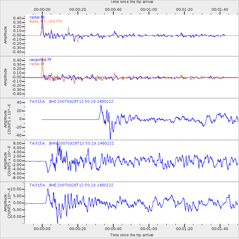
Signal To Noise
| Channel | StoN | STA | LTA |
| TA:F15A: :BHN:20070928T13:50:29.148022Z | 39.092873 | 2.3077296E-6 | 5.9031976E-8 |
| TA:F15A: :BHE:20070928T13:50:29.148022Z | 35.06204 | 4.0657915E-6 | 1.1595993E-7 |
| TA:F15A: :BHZ:20070928T13:50:29.148022Z | 119.02851 | 1.3200361E-5 | 1.10900835E-7 |
| Arrivals |
| Ps | 5.4 SECOND |
| PpPs | 17 SECOND |
| PsPs/PpSs | 23 SECOND |


