You are here: Home > Network List > II - Global Seismograph Network (GSN - IRIS/IDA) Stations List
> Station WRAB Tennant Creek, NT, Australia > Earthquake Result Viewer
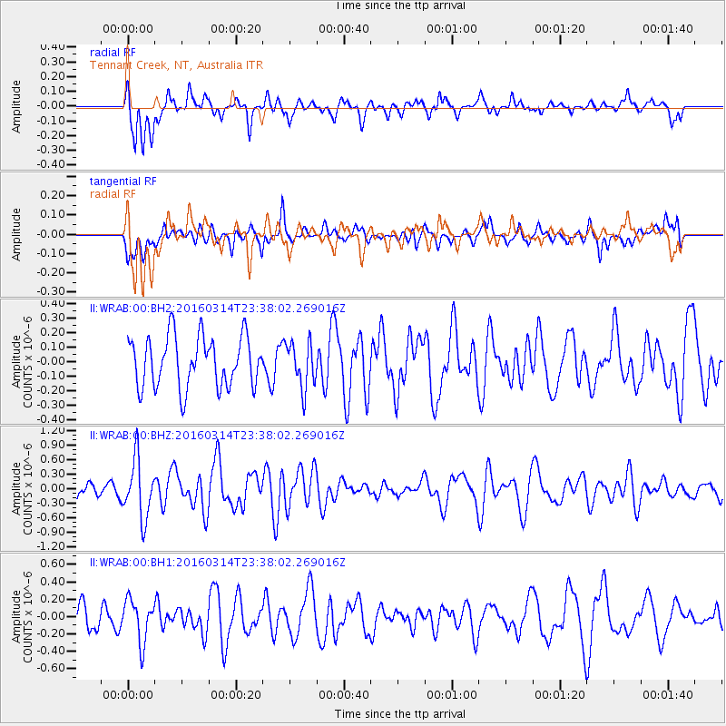
WRAB Tennant Creek, NT, Australia - Earthquake Result Viewer
*The percent match for this event was below the threshold and hence no stack was calculated.
| Earthquake location: |
Southwest Of Africa |
| Earthquake latitude/longitude: |
-52.6/18.9 |
| Earthquake time(UTC): |
2016/03/14 (074) 23:25:40 GMT |
| Earthquake Depth: |
10 km |
| Earthquake Magnitude: |
5.8 MWP |
| Earthquake Catalog/Contributor: |
NEIC PDE/NEIC COMCAT |
|
| Network: |
II Global Seismograph Network (GSN - IRIS/IDA) |
| Station: |
WRAB Tennant Creek, NT, Australia |
| Lat/Lon: |
19.93 S/134.36 E |
| Elevation: |
366 m |
|
| Distance: |
88.7 deg |
| Az: |
121.859 deg |
| Baz: |
213.377 deg |
| Ray Param: |
$rayparam |
*The percent match for this event was below the threshold and hence was not used in the summary stack. |
|
| Radial Match: |
69.41525 % |
| Radial Bump: |
400 |
| Transverse Match: |
43.7615 % |
| Transverse Bump: |
400 |
| SOD ConfigId: |
1453031 |
| Insert Time: |
2016-03-28 23:40:50.670 +0000 |
| GWidth: |
2.5 |
| Max Bumps: |
400 |
| Tol: |
0.001 |
|
Signal To Noise
| Channel | StoN | STA | LTA |
| II:WRAB:00:BHZ:20160314T23:38:02.269016Z | 3.45451 | 6.032521E-7 | 1.746274E-7 |
| II:WRAB:00:BH1:20160314T23:38:02.269016Z | 1.8743787 | 2.4723803E-7 | 1.31904E-7 |
| II:WRAB:00:BH2:20160314T23:38:02.269016Z | 0.90502656 | 1.5891233E-7 | 1.7558857E-7 |
| Arrivals |
| Ps | |
| PpPs | |
| PsPs/PpSs | |


