You are here: Home > Network List > TA - USArray Transportable Network (new EarthScope stations) Stations List
> Station 121A Cookes Peak, Deming, NM, USA > Earthquake Result Viewer
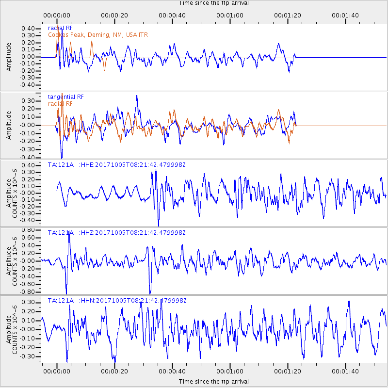
121A Cookes Peak, Deming, NM, USA - Earthquake Result Viewer
*The percent match for this event was below the threshold and hence no stack was calculated.
| Earthquake location: |
Northern Chile |
| Earthquake latitude/longitude: |
-22.4/-68.6 |
| Earthquake time(UTC): |
2017/10/05 (278) 08:11:36 GMT |
| Earthquake Depth: |
113 km |
| Earthquake Magnitude: |
5.4 Mww |
| Earthquake Catalog/Contributor: |
NEIC PDE/us |
|
| Network: |
TA USArray Transportable Network (new EarthScope stations) |
| Station: |
121A Cookes Peak, Deming, NM, USA |
| Lat/Lon: |
32.53 N/107.79 W |
| Elevation: |
1652 m |
|
| Distance: |
66.2 deg |
| Az: |
324.308 deg |
| Baz: |
140.273 deg |
| Ray Param: |
$rayparam |
*The percent match for this event was below the threshold and hence was not used in the summary stack. |
|
| Radial Match: |
57.807693 % |
| Radial Bump: |
400 |
| Transverse Match: |
69.20584 % |
| Transverse Bump: |
400 |
| SOD ConfigId: |
13570011 |
| Insert Time: |
2019-04-28 22:20:49.982 +0000 |
| GWidth: |
2.5 |
| Max Bumps: |
400 |
| Tol: |
0.001 |
|
Signal To Noise
| Channel | StoN | STA | LTA |
| TA:121A: :HHZ:20171005T08:21:42.479998Z | 3.2620482 | 3.18851E-7 | 9.774564E-8 |
| TA:121A: :HHN:20171005T08:21:42.479998Z | 1.3270319 | 1.2326204E-7 | 9.2885514E-8 |
| TA:121A: :HHE:20171005T08:21:42.479998Z | 1.938122 | 1.362938E-7 | 7.032261E-8 |
| Arrivals |
| Ps | |
| PpPs | |
| PsPs/PpSs | |


