You are here: Home > Network List > TA - USArray Transportable Network (new EarthScope stations) Stations List
> Station F15A Butte, MT, USA > Earthquake Result Viewer
F15A Butte, MT, USA - Earthquake Result Viewer

| Earthquake location: |
Northwest Of Ryukyu Islands |
| Earthquake latitude/longitude: |
27.3/126.9 |
| Earthquake time(UTC): |
2007/07/31 (212) 15:07:35 GMT |
| Earthquake Depth: |
10 km |
| Earthquake Magnitude: |
5.5 MB, 5.7 MS, 5.9 MW, 5.9 MW |
| Earthquake Catalog/Contributor: |
WHDF/NEIC |
|
| Network: |
TA USArray Transportable Network (new EarthScope stations) |
| Station: |
F15A Butte, MT, USA |
| Lat/Lon: |
45.84 N/112.49 W |
| Elevation: |
1995 m |
|
| Distance: |
89.4 deg |
| Az: |
36.99 deg |
| Baz: |
310.039 deg |
| Ray Param: |
0.041861042 |
| Estimated Moho Depth: |
25.25 km |
| Estimated Crust Vp/Vs: |
1.90 |
| Assumed Crust Vp: |
6.577 km/s |
| Estimated Crust Vs: |
3.457 km/s |
| Estimated Crust Poisson's Ratio: |
0.31 |
|
| Radial Match: |
81.07754 % |
| Radial Bump: |
324 |
| Transverse Match: |
68.810616 % |
| Transverse Bump: |
400 |
| SOD ConfigId: |
2564 |
| Insert Time: |
2010-03-06 04:56:19.103 +0000 |
| GWidth: |
2.5 |
| Max Bumps: |
400 |
| Tol: |
0.001 |
|
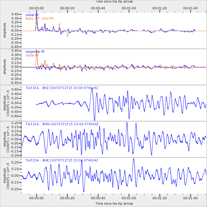
Signal To Noise
| Channel | StoN | STA | LTA |
| TA:F15A: :BHN:20070731T15:20:00.674004Z | 1.5203224 | 5.993276E-8 | 3.9421085E-8 |
| TA:F15A: :BHE:20070731T15:20:00.674004Z | 1.9344466 | 4.2449933E-8 | 2.1944226E-8 |
| TA:F15A: :BHZ:20070731T15:20:00.674004Z | 2.9357252 | 1.4465977E-7 | 4.927565E-8 |
| Arrivals |
| Ps | 3.5 SECOND |
| PpPs | 11 SECOND |
| PsPs/PpSs | 14 SECOND |


