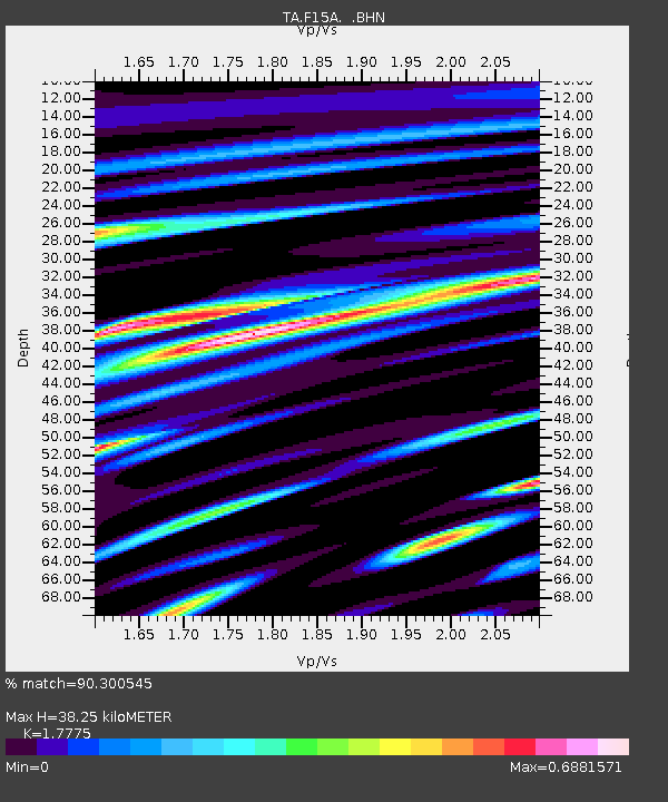
F15A Butte, MT, USA - Earthquake Result Viewer
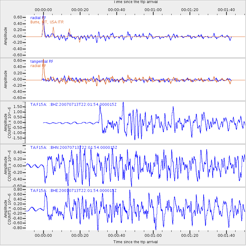
Earthquake location: Andreanof Islands, Aleutian Is.
Earthquake latitude/longitude: 51.8/-176.3
Earthquake time(UTC): 2007/07/13 (194) 21:54:43 GMT
Earthquake Depth: 35 km
Earthquake Magnitude: 5.7 MB, 5.6 MS, 6.0 MW, 5.9 MW
Earthquake Catalog/Contributor: WHDF/NEIC
Network: TA USArray Transportable Network (new EarthScope stations)
Station: F15A Butte, MT, USA
Lat/Lon: 45.84 N/112.49 W
Elevation: 1995 m
Distance: 41.2 deg
Az: 72.188 deg
Baz: 302.327 deg
Ray Param: 0.073865354
Estimated Moho Depth: 38.25 km
Estimated Crust Vp/Vs: 1.78
Assumed Crust Vp: 6.577 km/s
Estimated Crust Vs: 3.7 km/s
Estimated Crust Poisson's Ratio: 0.27
Radial Match: 90.300545 %
Radial Bump: 400
Transverse Match: 81.27717 %
Transverse Bump: 400
SOD ConfigId: 2564
Insert Time: 2010-03-06 04:56:31.936 +0000
GWidth: 2.5
Max Bumps: 400
Tol: 0.001

Signal To Noise

ChannelStoNSTALTA
TA:F15A: :BHN:20070713T22:01:54.000015Z6.23735432.3826736E-73.8200067E-8
TA:F15A: :BHE:20070713T22:01:54.000015Z8.4417713.4512334E-74.0882814E-8
TA:F15A: :BHZ:20070713T22:01:54.000015Z15.7498857.407668E-74.7033158E-8
Arrivals
Ps4.9 SECOND
PpPs15 SECOND
PsPs/PpSs20 SECOND