You are here: Home > Network List > TA - USArray Transportable Network (new EarthScope stations) Stations List
> Station F15A Butte, MT, USA > Earthquake Result Viewer
F15A Butte, MT, USA - Earthquake Result Viewer
| Earthquake location: |
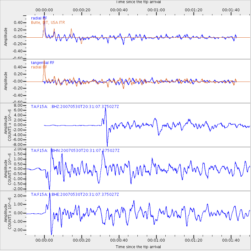
Kamchatka Peninsula, Russia |
| Earthquake latitude/longitude: |
52.1/157.3 |
| Earthquake time(UTC): |
2007/05/30 (150) 20:22:12 GMT |
| Earthquake Depth: |
116 km |
| Earthquake Magnitude: |
6.4 MB, 6.4 MW, 6.4 MW |
| Earthquake Catalog/Contributor: |
WHDF/NEIC |
|
| Network: |
TA USArray Transportable Network (new EarthScope stations) |
| Station: |
F15A Butte, MT, USA |
| Lat/Lon: |
45.84 N/112.49 W |
| Elevation: |
1995 m |
|
| Distance: |
55.8 deg |
| Az: |
57.65 deg |
| Baz: |
311.855 deg |
| Ray Param: |
0.064172104 |
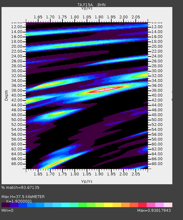
| Estimated Moho Depth: |
37.5 km |
| Estimated Crust Vp/Vs: |
1.92 |
| Assumed Crust Vp: |
6.577 km/s |
| Estimated Crust Vs: |
3.425 km/s |
| Estimated Crust Poisson's Ratio: |
0.31 |
|
| Radial Match: |
93.67135 % |
| Radial Bump: |
381 |
| Transverse Match: |
83.11677 % |
| Transverse Bump: |
400 |
| SOD ConfigId: |
2564 |
| Insert Time: |
2010-03-06 04:56:38.226 +0000 |
| GWidth: |
2.5 |
| Max Bumps: |
400 |
| Tol: |
0.001 |
|
Signal To Noise
| Channel | StoN | STA | LTA |
| TA:F15A: :BHN:20070530T20:31:07.375027Z | 18.252296 | 1.0531616E-6 | 5.770022E-8 |
| TA:F15A: :BHE:20070530T20:31:07.375027Z | 34.66459 | 1.2175032E-6 | 3.5122387E-8 |
| TA:F15A: :BHZ:20070530T20:31:07.375027Z | 63.213722 | 3.5501278E-6 | 5.6160715E-8 |
| Arrivals |
| Ps | 5.5 SECOND |
| PpPs | 16 SECOND |
| PsPs/PpSs | 21 SECOND |


