You are here: Home > Network List > TA - USArray Transportable Network (new EarthScope stations) Stations List
> Station F15A Butte, MT, USA > Earthquake Result Viewer
F15A Butte, MT, USA - Earthquake Result Viewer

| Earthquake location: |
Solomon Islands |
| Earthquake latitude/longitude: |
-7.3/155.7 |
| Earthquake time(UTC): |
2007/04/01 (091) 21:11:33 GMT |
| Earthquake Depth: |
10 km |
| Earthquake Magnitude: |
6.3 MB |
| Earthquake Catalog/Contributor: |
WHDF/NEIC |
|
| Network: |
TA USArray Transportable Network (new EarthScope stations) |
| Station: |
F15A Butte, MT, USA |
| Lat/Lon: |
45.84 N/112.49 W |
| Elevation: |
1995 m |
|
| Distance: |
96.4 deg |
| Az: |
44.678 deg |
| Baz: |
266.166 deg |
| Ray Param: |
0.04052316 |
| Estimated Moho Depth: |
49.25 km |
| Estimated Crust Vp/Vs: |
1.78 |
| Assumed Crust Vp: |
6.577 km/s |
| Estimated Crust Vs: |
3.69 km/s |
| Estimated Crust Poisson's Ratio: |
0.27 |
|
| Radial Match: |
86.24923 % |
| Radial Bump: |
400 |
| Transverse Match: |
49.808567 % |
| Transverse Bump: |
298 |
| SOD ConfigId: |
2564 |
| Insert Time: |
2010-03-06 04:56:39.607 +0000 |
| GWidth: |
2.5 |
| Max Bumps: |
400 |
| Tol: |
0.001 |
|
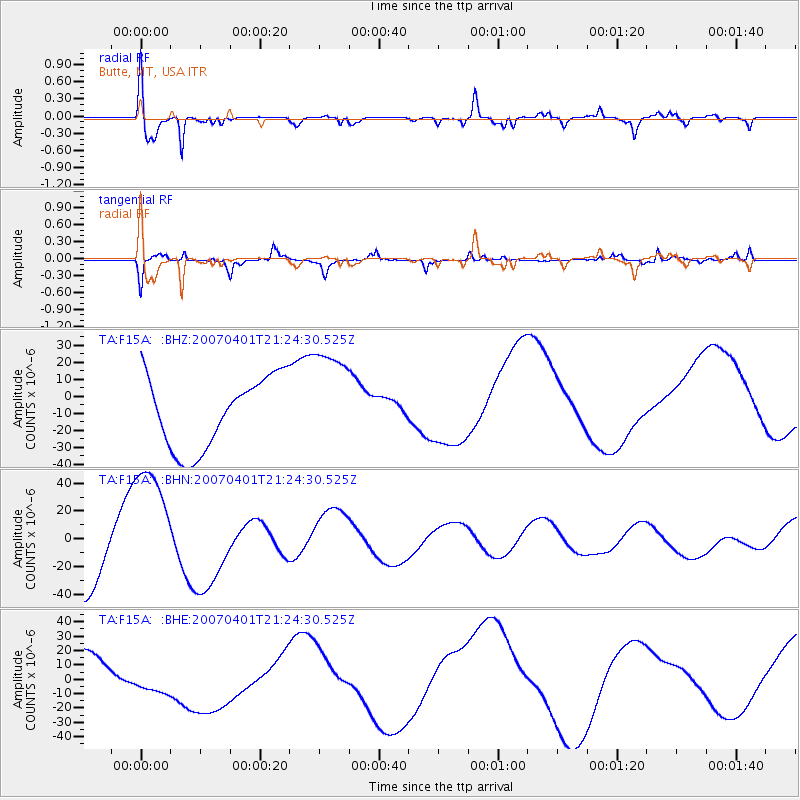
Signal To Noise
| Channel | StoN | STA | LTA |
| TA:F15A: :BHN:20070401T21:24:30.525Z | 2.4422727 | 4.6724086E-5 | 1.9131397E-5 |
| TA:F15A: :BHE:20070401T21:24:30.525Z | 0.46394894 | 1.0677832E-5 | 2.3015102E-5 |
| TA:F15A: :BHZ:20070401T21:24:30.525Z | 1.4989914 | 3.1384203E-5 | 2.093688E-5 |
| Arrivals |
| Ps | 6.0 SECOND |
| PpPs | 20 SECOND |
| PsPs/PpSs | 26 SECOND |


