You are here: Home > Network List > GS - US Geological Survey Networks Stations List
> Station KAN08 Pence Farm, Harper, KS, USA > Earthquake Result Viewer
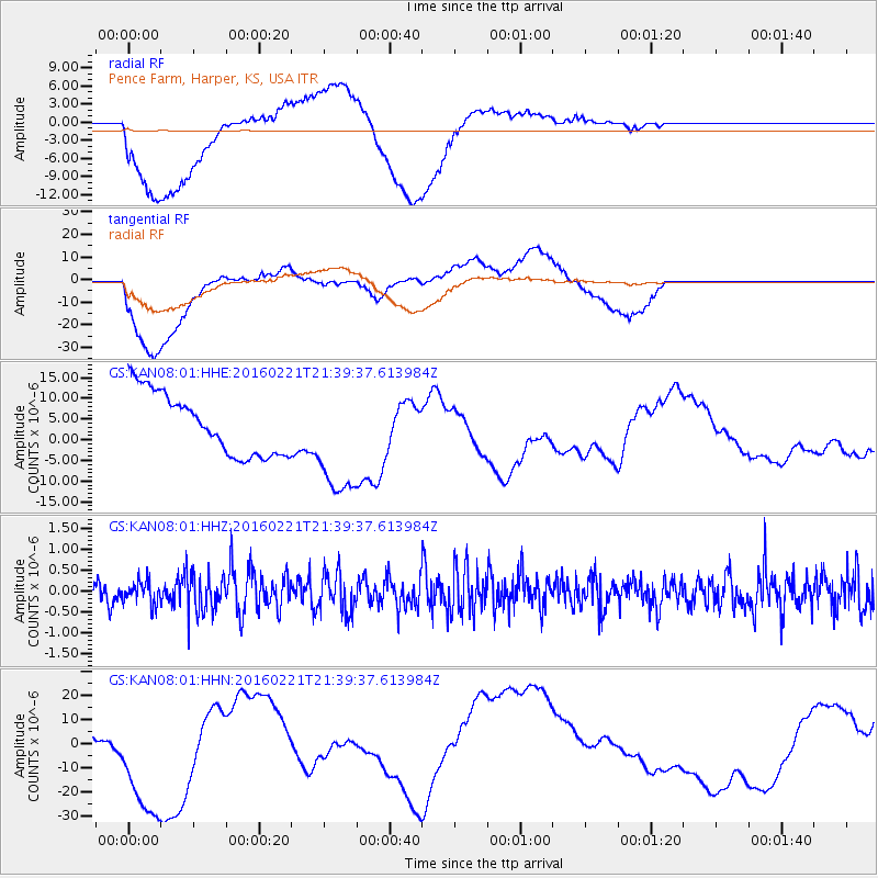
KAN08 Pence Farm, Harper, KS, USA - Earthquake Result Viewer
*The percent match for this event was below the threshold and hence no stack was calculated.
| Earthquake location: |
Volcano Islands, Japan Region |
| Earthquake latitude/longitude: |
24.6/142.4 |
| Earthquake time(UTC): |
2016/02/21 (052) 21:26:42 GMT |
| Earthquake Depth: |
21 km |
| Earthquake Magnitude: |
5.6 MB, 5.5 MWB, 5.7 MWW |
| Earthquake Catalog/Contributor: |
NEIC PDE/NEIC COMCAT |
|
| Network: |
GS US Geological Survey Networks |
| Station: |
KAN08 Pence Farm, Harper, KS, USA |
| Lat/Lon: |
37.23 N/97.97 W |
| Elevation: |
375 m |
|
| Distance: |
96.3 deg |
| Az: |
44.279 deg |
| Baz: |
307.203 deg |
| Ray Param: |
$rayparam |
*The percent match for this event was below the threshold and hence was not used in the summary stack. |
|
| Radial Match: |
61.804195 % |
| Radial Bump: |
400 |
| Transverse Match: |
44.229412 % |
| Transverse Bump: |
400 |
| SOD ConfigId: |
1453031 |
| Insert Time: |
2016-03-28 23:44:30.429 +0000 |
| GWidth: |
2.5 |
| Max Bumps: |
400 |
| Tol: |
0.001 |
|
Signal To Noise
| Channel | StoN | STA | LTA |
| GS:KAN08:01:HHZ:20160221T21:39:37.613984Z | 0.8344571 | 2.767371E-7 | 3.316373E-7 |
| GS:KAN08:01:HHN:20160221T21:39:37.613984Z | 5.573843 | 2.8761946E-5 | 5.160164E-6 |
| GS:KAN08:01:HHE:20160221T21:39:37.613984Z | 1.840838 | 1.3730113E-5 | 7.4586214E-6 |
| Arrivals |
| Ps | |
| PpPs | |
| PsPs/PpSs | |


