You are here: Home > Network List > TA - USArray Transportable Network (new EarthScope stations) Stations List
> Station M53A WI Miller and Sons, Farmdale, OH, USA > Earthquake Result Viewer
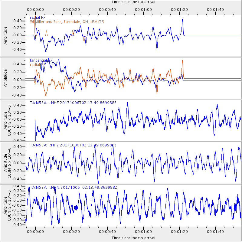
M53A WI Miller and Sons, Farmdale, OH, USA - Earthquake Result Viewer
*The percent match for this event was below the threshold and hence no stack was calculated.
| Earthquake location: |
Central Mid-Atlantic Ridge |
| Earthquake latitude/longitude: |
1.0/-25.5 |
| Earthquake time(UTC): |
2017/10/06 (279) 02:03:48 GMT |
| Earthquake Depth: |
10 km |
| Earthquake Magnitude: |
5.5 Mww |
| Earthquake Catalog/Contributor: |
NEIC PDE/us |
|
| Network: |
TA USArray Transportable Network (new EarthScope stations) |
| Station: |
M53A WI Miller and Sons, Farmdale, OH, USA |
| Lat/Lon: |
41.44 N/80.68 W |
| Elevation: |
334 m |
|
| Distance: |
63.9 deg |
| Az: |
316.579 deg |
| Baz: |
113.924 deg |
| Ray Param: |
$rayparam |
*The percent match for this event was below the threshold and hence was not used in the summary stack. |
|
| Radial Match: |
46.22369 % |
| Radial Bump: |
400 |
| Transverse Match: |
35.48419 % |
| Transverse Bump: |
400 |
| SOD ConfigId: |
13570011 |
| Insert Time: |
2019-04-28 22:28:48.222 +0000 |
| GWidth: |
2.5 |
| Max Bumps: |
400 |
| Tol: |
0.001 |
|
Signal To Noise
| Channel | StoN | STA | LTA |
| TA:M53A: :HHZ:20171006T02:13:49.869988Z | 0.9629846 | 1.5875885E-7 | 1.6486125E-7 |
| TA:M53A: :HHN:20171006T02:13:49.869988Z | 0.70832956 | 1.834951E-7 | 2.5905328E-7 |
| TA:M53A: :HHE:20171006T02:13:49.869988Z | 1.1594552 | 2.200353E-7 | 1.8977472E-7 |
| Arrivals |
| Ps | |
| PpPs | |
| PsPs/PpSs | |


