You are here: Home > Network List > UW - Pacific Northwest Regional Seismic Network Stations List
> Station GNW Green Mountain (BB) > Earthquake Result Viewer
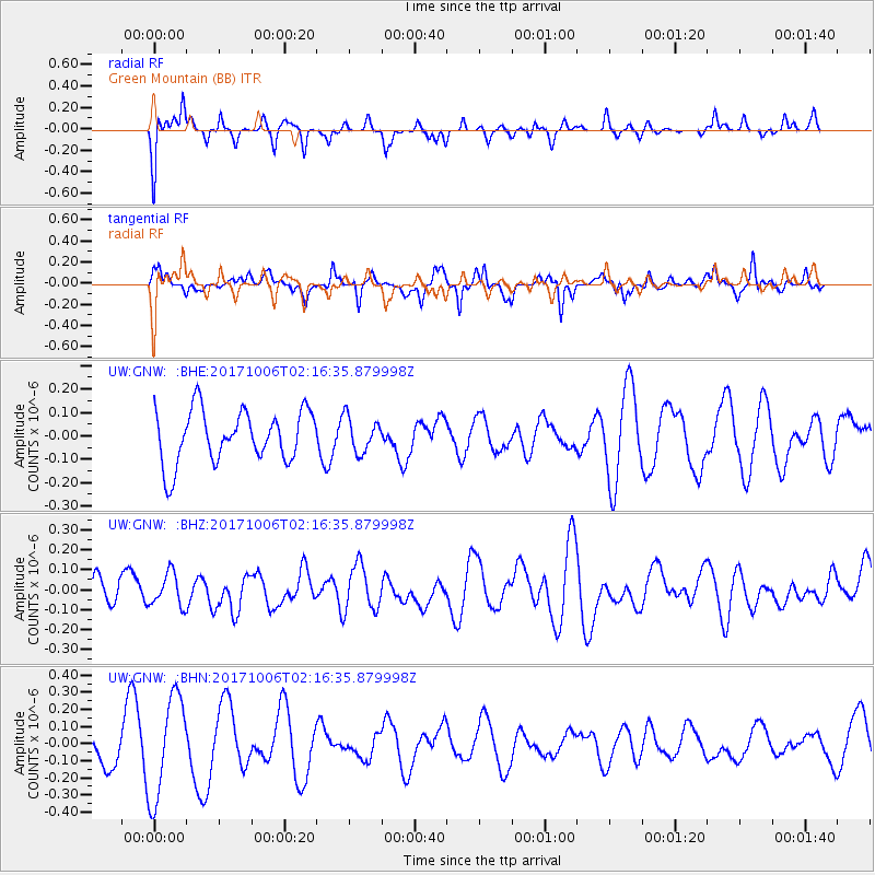
GNW Green Mountain (BB) - Earthquake Result Viewer
*The percent match for this event was below the threshold and hence no stack was calculated.
| Earthquake location: |
Central Mid-Atlantic Ridge |
| Earthquake latitude/longitude: |
1.0/-25.5 |
| Earthquake time(UTC): |
2017/10/06 (279) 02:03:48 GMT |
| Earthquake Depth: |
10 km |
| Earthquake Magnitude: |
5.5 Mww |
| Earthquake Catalog/Contributor: |
NEIC PDE/us |
|
| Network: |
UW Pacific Northwest Regional Seismic Network |
| Station: |
GNW Green Mountain (BB) |
| Lat/Lon: |
47.56 N/122.83 W |
| Elevation: |
160 m |
|
| Distance: |
94.2 deg |
| Az: |
317.657 deg |
| Baz: |
83.961 deg |
| Ray Param: |
$rayparam |
*The percent match for this event was below the threshold and hence was not used in the summary stack. |
|
| Radial Match: |
51.27658 % |
| Radial Bump: |
333 |
| Transverse Match: |
38.396393 % |
| Transverse Bump: |
310 |
| SOD ConfigId: |
13570011 |
| Insert Time: |
2019-04-28 22:29:33.746 +0000 |
| GWidth: |
2.5 |
| Max Bumps: |
400 |
| Tol: |
0.001 |
|
Signal To Noise
| Channel | StoN | STA | LTA |
| UW:GNW: :BHZ:20171006T02:16:35.879998Z | 0.83067983 | 8.238691E-8 | 9.9180106E-8 |
| UW:GNW: :BHN:20171006T02:16:35.879998Z | 3.8566678 | 2.9747258E-7 | 7.713202E-8 |
| UW:GNW: :BHE:20171006T02:16:35.879998Z | 0.6660752 | 7.391373E-8 | 1.1096904E-7 |
| Arrivals |
| Ps | |
| PpPs | |
| PsPs/PpSs | |


