You are here: Home > Network List > IU - Global Seismograph Network (GSN - IRIS/USGS) Stations List
> Station MAKZ Makanchi, Kazakhstan > Earthquake Result Viewer
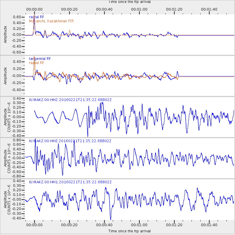
MAKZ Makanchi, Kazakhstan - Earthquake Result Viewer
*The percent match for this event was below the threshold and hence no stack was calculated.
| Earthquake location: |
Volcano Islands, Japan Region |
| Earthquake latitude/longitude: |
24.6/142.4 |
| Earthquake time(UTC): |
2016/02/21 (052) 21:26:42 GMT |
| Earthquake Depth: |
21 km |
| Earthquake Magnitude: |
5.6 MB, 5.5 MWB, 5.7 MWW |
| Earthquake Catalog/Contributor: |
NEIC PDE/NEIC COMCAT |
|
| Network: |
IU Global Seismograph Network (GSN - IRIS/USGS) |
| Station: |
MAKZ Makanchi, Kazakhstan |
| Lat/Lon: |
46.81 N/81.98 E |
| Elevation: |
600 m |
|
| Distance: |
52.5 deg |
| Az: |
311.132 deg |
| Baz: |
93.09 deg |
| Ray Param: |
$rayparam |
*The percent match for this event was below the threshold and hence was not used in the summary stack. |
|
| Radial Match: |
67.93458 % |
| Radial Bump: |
382 |
| Transverse Match: |
47.701168 % |
| Transverse Bump: |
347 |
| SOD ConfigId: |
1453031 |
| Insert Time: |
2016-03-28 23:46:14.808 +0000 |
| GWidth: |
2.5 |
| Max Bumps: |
400 |
| Tol: |
0.001 |
|
Signal To Noise
| Channel | StoN | STA | LTA |
| IU:MAKZ:00:HHZ:20160221T21:35:22.68802Z | 2.5179129 | 3.0352587E-7 | 1.205466E-7 |
| IU:MAKZ:00:HH1:20160221T21:35:22.68802Z | 0.7664765 | 1.0929849E-7 | 1.4259861E-7 |
| IU:MAKZ:00:HH2:20160221T21:35:22.68802Z | 1.9033039 | 1.4687929E-7 | 7.71707E-8 |
| Arrivals |
| Ps | |
| PpPs | |
| PsPs/PpSs | |


