You are here: Home > Network List > CI - Caltech Regional Seismic Network Stations List
> Station SMM Simmler, CA, USA > Earthquake Result Viewer
SMM Simmler, CA, USA - Earthquake Result Viewer
| Earthquake location: |
Southeast Of Honshu, Japan |
| Earthquake latitude/longitude: |
32.8/140.4 |
| Earthquake time(UTC): |
2009/08/12 (224) 22:48:51 GMT |
| Earthquake Depth: |
53 km |
| Earthquake Magnitude: |
6.2 MB, 6.6 MW, 6.6 MW |
| Earthquake Catalog/Contributor: |
WHDF/NEIC |
|
| Network: |
CI Caltech Regional Seismic Network |
| Station: |
SMM Simmler, CA, USA |
| Lat/Lon: |
35.31 N/120.00 W |
| Elevation: |
599 m |
|
| Distance: |
78.7 deg |
| Az: |
55.307 deg |
| Baz: |
302.163 deg |
| Ray Param: |
0.049348056 |
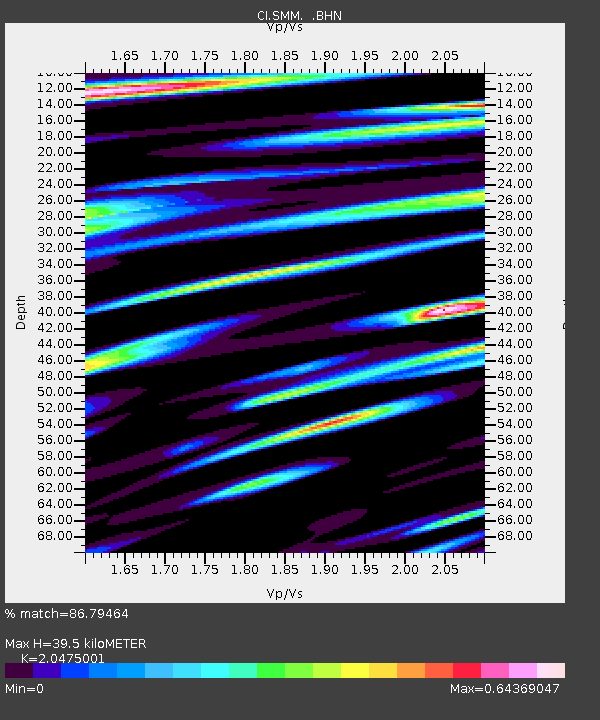
| Estimated Moho Depth: |
39.5 km |
| Estimated Crust Vp/Vs: |
2.05 |
| Assumed Crust Vp: |
6.1 km/s |
| Estimated Crust Vs: |
2.979 km/s |
| Estimated Crust Poisson's Ratio: |
0.34 |
|
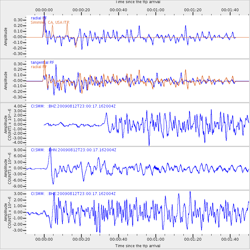
| Radial Match: |
86.79464 % |
| Radial Bump: |
400 |
| Transverse Match: |
77.223274 % |
| Transverse Bump: |
400 |
| SOD ConfigId: |
2622 |
| Insert Time: |
2010-02-26 01:30:51.252 +0000 |
| GWidth: |
2.5 |
| Max Bumps: |
400 |
| Tol: |
0.001 |
|
Signal To Noise
| Channel | StoN | STA | LTA |
| CI:SMM: :BHN:20090812T23:00:17.162004Z | 33.253094 | 4.4986186E-6 | 1.3528421E-7 |
| CI:SMM: :BHE:20090812T23:00:17.162004Z | 4.2699327 | 1.1132736E-6 | 2.607239E-7 |
| CI:SMM: :BHZ:20090812T23:00:17.162004Z | 4.996089 | 1.0086491E-6 | 2.0188773E-7 |
| Arrivals |
| Ps | 6.9 SECOND |
| PpPs | 19 SECOND |
| PsPs/PpSs | 26 SECOND |


