You are here: Home > Network List > CI - Caltech Regional Seismic Network Stations List
> Station BAR Barrett, Tecate, CA, USA > Earthquake Result Viewer
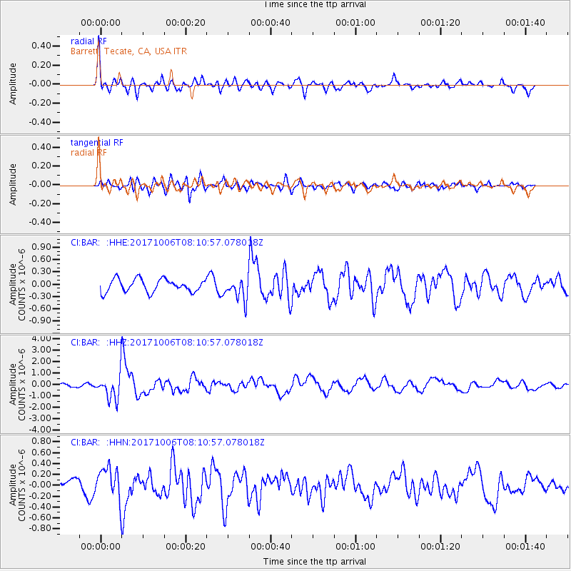
BAR Barrett, Tecate, CA, USA - Earthquake Result Viewer
*The percent match for this event was below the threshold and hence no stack was calculated.
| Earthquake location: |
Off East Coast Of Honshu, Japan |
| Earthquake latitude/longitude: |
37.5/144.0 |
| Earthquake time(UTC): |
2017/10/06 (279) 07:59:33 GMT |
| Earthquake Depth: |
10 km |
| Earthquake Magnitude: |
6.0 Mww |
| Earthquake Catalog/Contributor: |
NEIC PDE/us |
|
| Network: |
CI Caltech Regional Seismic Network |
| Station: |
BAR Barrett, Tecate, CA, USA |
| Lat/Lon: |
32.68 N/116.67 W |
| Elevation: |
521 m |
|
| Distance: |
77.5 deg |
| Az: |
58.459 deg |
| Baz: |
306.496 deg |
| Ray Param: |
$rayparam |
*The percent match for this event was below the threshold and hence was not used in the summary stack. |
|
| Radial Match: |
77.88486 % |
| Radial Bump: |
400 |
| Transverse Match: |
62.350452 % |
| Transverse Bump: |
400 |
| SOD ConfigId: |
13570011 |
| Insert Time: |
2019-04-28 22:33:40.972 +0000 |
| GWidth: |
2.5 |
| Max Bumps: |
400 |
| Tol: |
0.001 |
|
Signal To Noise
| Channel | StoN | STA | LTA |
| CI:BAR: :HHZ:20171006T08:10:57.078018Z | 7.488835 | 1.1128121E-6 | 1.4859616E-7 |
| CI:BAR: :HHN:20171006T08:10:57.078018Z | 1.6610541 | 3.0790915E-7 | 1.8536971E-7 |
| CI:BAR: :HHE:20171006T08:10:57.078018Z | 2.2116215 | 3.4360284E-7 | 1.553624E-7 |
| Arrivals |
| Ps | |
| PpPs | |
| PsPs/PpSs | |


