You are here: Home > Network List > CN - Canadian National Seismograph Network Stations List
> Station INK INUVIK, NT > Earthquake Result Viewer
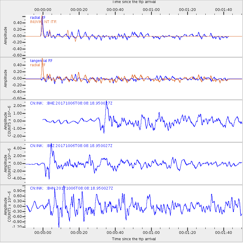
INK INUVIK, NT - Earthquake Result Viewer
*The percent match for this event was below the threshold and hence no stack was calculated.
| Earthquake location: |
Off East Coast Of Honshu, Japan |
| Earthquake latitude/longitude: |
37.5/144.0 |
| Earthquake time(UTC): |
2017/10/06 (279) 07:59:33 GMT |
| Earthquake Depth: |
10 km |
| Earthquake Magnitude: |
6.0 Mww |
| Earthquake Catalog/Contributor: |
NEIC PDE/us |
|
| Network: |
CN Canadian National Seismograph Network |
| Station: |
INK INUVIK, NT |
| Lat/Lon: |
68.31 N/133.53 W |
| Elevation: |
44 m |
|
| Distance: |
53.1 deg |
| Az: |
27.467 deg |
| Baz: |
279.301 deg |
| Ray Param: |
$rayparam |
*The percent match for this event was below the threshold and hence was not used in the summary stack. |
|
| Radial Match: |
77.526146 % |
| Radial Bump: |
400 |
| Transverse Match: |
69.38095 % |
| Transverse Bump: |
400 |
| SOD ConfigId: |
13570011 |
| Insert Time: |
2019-04-28 22:34:47.904 +0000 |
| GWidth: |
2.5 |
| Max Bumps: |
400 |
| Tol: |
0.001 |
|
Signal To Noise
| Channel | StoN | STA | LTA |
| CN:INK: :BHZ:20171006T08:08:18.950027Z | 13.659902 | 2.2758036E-6 | 1.6660469E-7 |
| CN:INK: :BHN:20171006T08:08:18.950027Z | 1.3392316 | 1.98007E-7 | 1.478512E-7 |
| CN:INK: :BHE:20171006T08:08:18.950027Z | 5.785559 | 9.375224E-7 | 1.6204524E-7 |
| Arrivals |
| Ps | |
| PpPs | |
| PsPs/PpSs | |


