You are here: Home > Network List > WY - Yellowstone Wyoming Seismic Network Stations List
> Station YHR Hawk's Rest, WY, USA > Earthquake Result Viewer
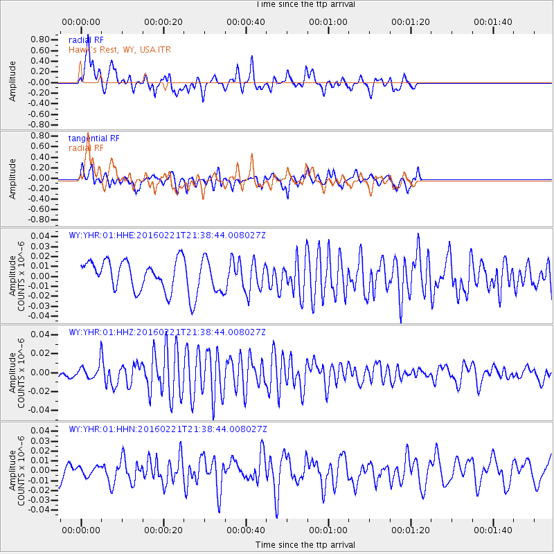
YHR Hawk's Rest, WY, USA - Earthquake Result Viewer
*The percent match for this event was below the threshold and hence no stack was calculated.
| Earthquake location: |
Volcano Islands, Japan Region |
| Earthquake latitude/longitude: |
24.6/142.4 |
| Earthquake time(UTC): |
2016/02/21 (052) 21:26:42 GMT |
| Earthquake Depth: |
21 km |
| Earthquake Magnitude: |
5.6 MB, 5.5 MWB, 5.7 MWW |
| Earthquake Catalog/Contributor: |
NEIC PDE/NEIC COMCAT |
|
| Network: |
WY Yellowstone Wyoming Seismic Network |
| Station: |
YHR Hawk's Rest, WY, USA |
| Lat/Lon: |
44.11 N/110.08 W |
| Elevation: |
2976 m |
|
| Distance: |
84.9 deg |
| Az: |
43.611 deg |
| Baz: |
299.318 deg |
| Ray Param: |
$rayparam |
*The percent match for this event was below the threshold and hence was not used in the summary stack. |
|
| Radial Match: |
69.308525 % |
| Radial Bump: |
400 |
| Transverse Match: |
66.281166 % |
| Transverse Bump: |
400 |
| SOD ConfigId: |
1453031 |
| Insert Time: |
2016-03-28 23:49:27.525 +0000 |
| GWidth: |
2.5 |
| Max Bumps: |
400 |
| Tol: |
0.001 |
|
Signal To Noise
| Channel | StoN | STA | LTA |
| WY:YHR:01:HHZ:20160221T21:38:44.008027Z | 0.98069704 | 7.526231E-9 | 7.674369E-9 |
| WY:YHR:01:HHN:20160221T21:38:44.008027Z | 0.6846384 | 4.857871E-9 | 7.0955286E-9 |
| WY:YHR:01:HHE:20160221T21:38:44.008027Z | 1.1621449 | 1.5945991E-8 | 1.3721173E-8 |
| Arrivals |
| Ps | |
| PpPs | |
| PsPs/PpSs | |


