You are here: Home > Network List > TA - USArray Transportable Network (new EarthScope stations) Stations List
> Station F15A Butte, MT, USA > Earthquake Result Viewer
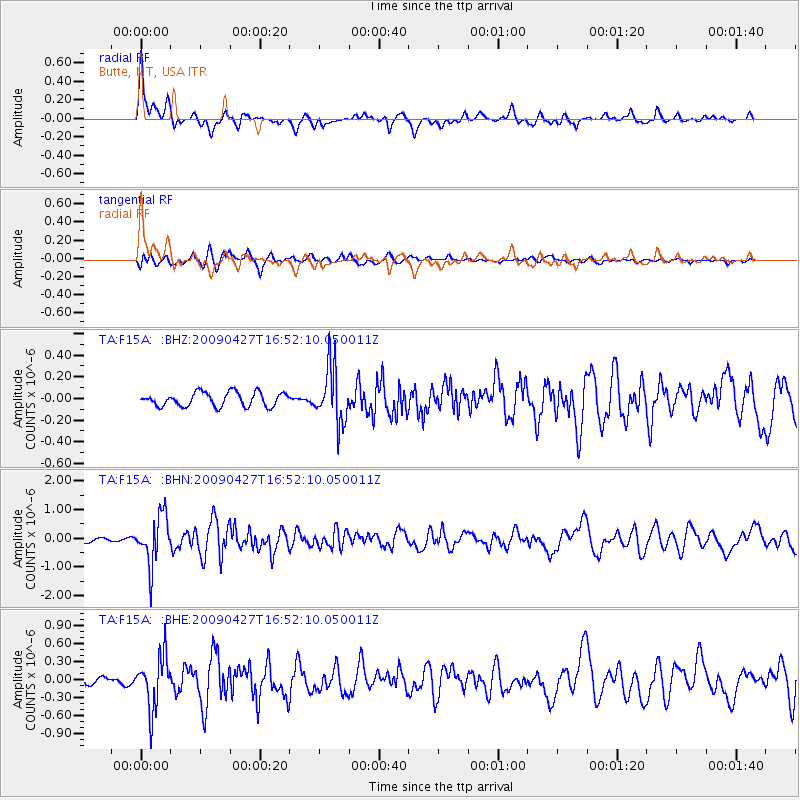
F15A Butte, MT, USA - Earthquake Result Viewer
*The percent match for this event was below the threshold and hence no stack was calculated.
| Earthquake location: |
Guerrero, Mexico |
| Earthquake latitude/longitude: |
17.0/-99.4 |
| Earthquake time(UTC): |
2009/04/27 (117) 16:46:28 GMT |
| Earthquake Depth: |
35 km |
| Earthquake Magnitude: |
5.7 MB, 5.4 MS, 5.8 MW, 5.8 MW |
| Earthquake Catalog/Contributor: |
WHDF/NEIC |
|
| Network: |
TA USArray Transportable Network (new EarthScope stations) |
| Station: |
F15A Butte, MT, USA |
| Lat/Lon: |
45.84 N/112.49 W |
| Elevation: |
1995 m |
|
| Distance: |
30.7 deg |
| Az: |
342.005 deg |
| Baz: |
154.99 deg |
| Ray Param: |
$rayparam |
*The percent match for this event was below the threshold and hence was not used in the summary stack. |
|
| Radial Match: |
77.72281 % |
| Radial Bump: |
400 |
| Transverse Match: |
67.81093 % |
| Transverse Bump: |
400 |
| SOD ConfigId: |
2658 |
| Insert Time: |
2010-03-06 04:59:42.357 +0000 |
| GWidth: |
2.5 |
| Max Bumps: |
400 |
| Tol: |
0.001 |
|
Signal To Noise
| Channel | StoN | STA | LTA |
| TA:F15A: :BHN:20090427T16:52:10.050011Z | 10.308943 | 8.5787804E-7 | 8.321688E-8 |
| TA:F15A: :BHE:20090427T16:52:10.050011Z | 7.5635777 | 4.3454696E-7 | 5.7452567E-8 |
| TA:F15A: :BHZ:20090427T16:52:10.050011Z | 4.0191503 | 2.5701993E-7 | 6.3948825E-8 |
| Arrivals |
| Ps | |
| PpPs | |
| PsPs/PpSs | |


