You are here: Home > Network List > KR - Kyrgyz Digital Network Stations List
> Station BTK Batken, Kyrgyzstan > Earthquake Result Viewer
BTK Batken, Kyrgyzstan - Earthquake Result Viewer
| Earthquake location: |
Off East Coast Of Honshu, Japan |
| Earthquake latitude/longitude: |
37.5/144.0 |
| Earthquake time(UTC): |
2017/10/06 (279) 07:59:33 GMT |
| Earthquake Depth: |
10 km |
| Earthquake Magnitude: |
6.0 Mww |
| Earthquake Catalog/Contributor: |
NEIC PDE/us |
|
| Network: |
KR Kyrgyz Digital Network |
| Station: |
BTK Batken, Kyrgyzstan |
| Lat/Lon: |
40.06 N/70.82 E |
| Elevation: |
980 m |
|
| Distance: |
55.6 deg |
| Az: |
297.048 deg |
| Baz: |
67.384 deg |
| Ray Param: |
0.06471652 |
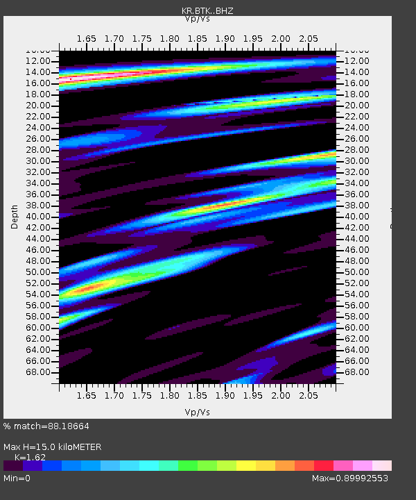
| Estimated Moho Depth: |
15.0 km |
| Estimated Crust Vp/Vs: |
1.62 |
| Assumed Crust Vp: |
6.236 km/s |
| Estimated Crust Vs: |
3.849 km/s |
| Estimated Crust Poisson's Ratio: |
0.19 |
|
| Radial Match: |
88.18664 % |
| Radial Bump: |
400 |
| Transverse Match: |
85.9975 % |
| Transverse Bump: |
400 |
| SOD ConfigId: |
13570011 |
| Insert Time: |
2019-04-28 22:36:45.485 +0000 |
| GWidth: |
2.5 |
| Max Bumps: |
400 |
| Tol: |
0.001 |
|

Signal To Noise
| Channel | StoN | STA | LTA |
| KR:BTK: :BHZ:20171006T08:08:37.72499Z | 30.902443 | 1.5673841E-6 | 5.0720395E-8 |
| KR:BTK: :BHN:20171006T08:08:37.72499Z | 6.093636 | 4.1944583E-7 | 6.883342E-8 |
| KR:BTK: :BHE:20171006T08:08:37.72499Z | 16.862268 | 6.437075E-7 | 3.8174427E-8 |
| Arrivals |
| Ps | 1.6 SECOND |
| PpPs | 6.0 SECOND |
| PsPs/PpSs | 7.5 SECOND |


