You are here: Home > Network List > TA - USArray Transportable Network (new EarthScope stations) Stations List
> Station F15A Butte, MT, USA > Earthquake Result Viewer
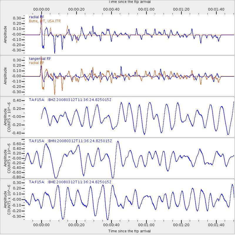
F15A Butte, MT, USA - Earthquake Result Viewer
*The percent match for this event was below the threshold and hence no stack was calculated.
| Earthquake location: |
Vanuatu Islands |
| Earthquake latitude/longitude: |
-16.6/167.3 |
| Earthquake time(UTC): |
2008/03/12 (072) 11:23:34 GMT |
| Earthquake Depth: |
13 km |
| Earthquake Magnitude: |
5.8 MB, 6.4 MS, 6.4 MW, 6.4 MW |
| Earthquake Catalog/Contributor: |
WHDF/NEIC |
|
| Network: |
TA USArray Transportable Network (new EarthScope stations) |
| Station: |
F15A Butte, MT, USA |
| Lat/Lon: |
45.84 N/112.49 W |
| Elevation: |
1995 m |
|
| Distance: |
95.1 deg |
| Az: |
43.749 deg |
| Baz: |
251.556 deg |
| Ray Param: |
$rayparam |
*The percent match for this event was below the threshold and hence was not used in the summary stack. |
|
| Radial Match: |
64.74672 % |
| Radial Bump: |
400 |
| Transverse Match: |
54.944603 % |
| Transverse Bump: |
400 |
| SOD ConfigId: |
2504 |
| Insert Time: |
2010-03-06 04:59:48.998 +0000 |
| GWidth: |
2.5 |
| Max Bumps: |
400 |
| Tol: |
0.001 |
|
Signal To Noise
| Channel | StoN | STA | LTA |
| TA:F15A: :BHN:20080312T11:36:24.825015Z | 2.6493342 | 4.1766455E-7 | 1.5764887E-7 |
| TA:F15A: :BHE:20080312T11:36:24.825015Z | 1.52809 | 1.08788235E-7 | 7.119229E-8 |
| TA:F15A: :BHZ:20080312T11:36:24.825015Z | 1.4901794 | 1.8070418E-7 | 1.2126337E-7 |
| Arrivals |
| Ps | |
| PpPs | |
| PsPs/PpSs | |


