You are here: Home > Network List > LD - Lamont-Doherty Cooperative Seismographic Network Stations List
> Station GEDE Greenville, DE, USA > Earthquake Result Viewer
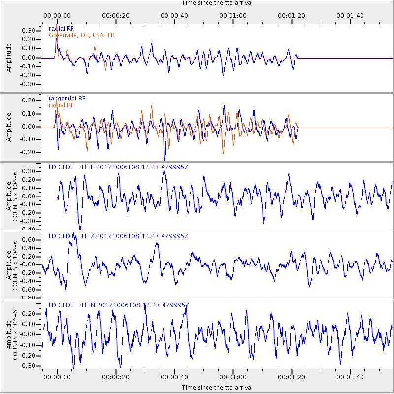
GEDE Greenville, DE, USA - Earthquake Result Viewer
*The percent match for this event was below the threshold and hence no stack was calculated.
| Earthquake location: |
Off East Coast Of Honshu, Japan |
| Earthquake latitude/longitude: |
37.5/144.0 |
| Earthquake time(UTC): |
2017/10/06 (279) 07:59:33 GMT |
| Earthquake Depth: |
10 km |
| Earthquake Magnitude: |
6.0 Mww |
| Earthquake Catalog/Contributor: |
NEIC PDE/us |
|
| Network: |
LD Lamont-Doherty Cooperative Seismographic Network |
| Station: |
GEDE Greenville, DE, USA |
| Lat/Lon: |
39.81 N/75.64 W |
| Elevation: |
105 m |
|
| Distance: |
94.9 deg |
| Az: |
29.518 deg |
| Baz: |
329.415 deg |
| Ray Param: |
$rayparam |
*The percent match for this event was below the threshold and hence was not used in the summary stack. |
|
| Radial Match: |
57.694126 % |
| Radial Bump: |
400 |
| Transverse Match: |
60.32319 % |
| Transverse Bump: |
400 |
| SOD ConfigId: |
13570011 |
| Insert Time: |
2019-04-28 22:37:08.104 +0000 |
| GWidth: |
2.5 |
| Max Bumps: |
400 |
| Tol: |
0.001 |
|
Signal To Noise
| Channel | StoN | STA | LTA |
| LD:GEDE: :HHZ:20171006T08:12:23.479995Z | 2.4503834 | 3.6848238E-7 | 1.5037743E-7 |
| LD:GEDE: :HHN:20171006T08:12:23.479995Z | 1.4833535 | 1.09152545E-7 | 7.3584985E-8 |
| LD:GEDE: :HHE:20171006T08:12:23.479995Z | 0.5863885 | 8.1040184E-8 | 1.382022E-7 |
| Arrivals |
| Ps | |
| PpPs | |
| PsPs/PpSs | |


