You are here: Home > Network List > TA - USArray Transportable Network (new EarthScope stations) Stations List
> Station F15A Butte, MT, USA > Earthquake Result Viewer
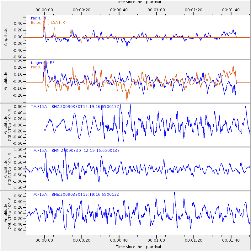
F15A Butte, MT, USA - Earthquake Result Viewer
*The percent match for this event was below the threshold and hence no stack was calculated.
| Earthquake location: |
Andreanof Islands, Aleutian Is. |
| Earthquake latitude/longitude: |
51.5/-178.3 |
| Earthquake time(UTC): |
2009/03/30 (089) 12:11:54 GMT |
| Earthquake Depth: |
31 km |
| Earthquake Magnitude: |
6.0 MB, 5.8 MW, 5.7 MW |
| Earthquake Catalog/Contributor: |
WHDF/NEIC |
|
| Network: |
TA USArray Transportable Network (new EarthScope stations) |
| Station: |
F15A Butte, MT, USA |
| Lat/Lon: |
45.84 N/112.49 W |
| Elevation: |
1995 m |
|
| Distance: |
42.5 deg |
| Az: |
70.741 deg |
| Baz: |
302.472 deg |
| Ray Param: |
$rayparam |
*The percent match for this event was below the threshold and hence was not used in the summary stack. |
|
| Radial Match: |
55.876133 % |
| Radial Bump: |
400 |
| Transverse Match: |
60.718937 % |
| Transverse Bump: |
400 |
| SOD ConfigId: |
2658 |
| Insert Time: |
2010-03-06 04:59:51.917 +0000 |
| GWidth: |
2.5 |
| Max Bumps: |
400 |
| Tol: |
0.001 |
|
Signal To Noise
| Channel | StoN | STA | LTA |
| TA:F15A: :BHN:20090330T12:19:16.650013Z | 3.743457 | 4.930573E-7 | 1.3171176E-7 |
| TA:F15A: :BHE:20090330T12:19:16.650013Z | 1.2691041 | 1.4795474E-7 | 1.1658204E-7 |
| TA:F15A: :BHZ:20090330T12:19:16.650013Z | 1.2025913 | 2.3439125E-7 | 1.9490516E-7 |
| Arrivals |
| Ps | |
| PpPs | |
| PsPs/PpSs | |


