You are here: Home > Network List > TA - USArray Transportable Network (new EarthScope stations) Stations List
> Station D15A Lincoln, MT, USA > Earthquake Result Viewer
D15A Lincoln, MT, USA - Earthquake Result Viewer
| Earthquake location: |
Komandorskiye Ostrova Region |
| Earthquake latitude/longitude: |
53.6/169.7 |
| Earthquake time(UTC): |
2007/07/29 (210) 04:54:36 GMT |
| Earthquake Depth: |
26 km |
| Earthquake Magnitude: |
6.0 MB, 5.5 MS, 5.9 MW, 5.8 MW |
| Earthquake Catalog/Contributor: |
WHDF/NEIC |
|
| Network: |
TA USArray Transportable Network (new EarthScope stations) |
| Station: |
D15A Lincoln, MT, USA |
| Lat/Lon: |
47.04 N/112.52 W |
| Elevation: |
1593 m |
|
| Distance: |
47.8 deg |
| Az: |
64.552 deg |
| Baz: |
308.174 deg |
| Ray Param: |
0.06974962 |
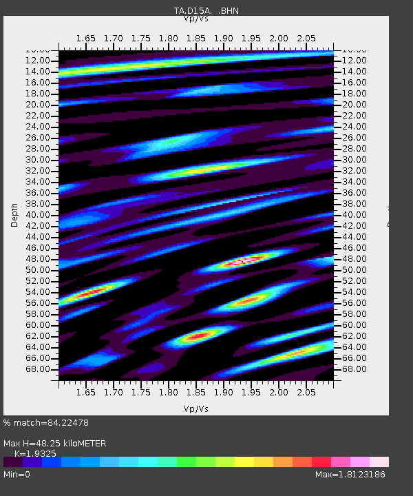
| Estimated Moho Depth: |
48.25 km |
| Estimated Crust Vp/Vs: |
1.93 |
| Assumed Crust Vp: |
6.353 km/s |
| Estimated Crust Vs: |
3.287 km/s |
| Estimated Crust Poisson's Ratio: |
0.32 |
|
| Radial Match: |
84.22478 % |
| Radial Bump: |
400 |
| Transverse Match: |
85.7394 % |
| Transverse Bump: |
400 |
| SOD ConfigId: |
2564 |
| Insert Time: |
2010-03-06 05:00:49.712 +0000 |
| GWidth: |
2.5 |
| Max Bumps: |
400 |
| Tol: |
0.001 |
|
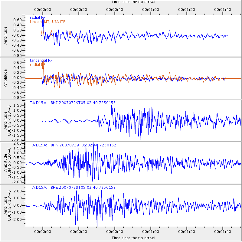
Signal To Noise
| Channel | StoN | STA | LTA |
| TA:D15A: :BHN:20070729T05:02:40.725015Z | 2.8776476 | 1.61984E-7 | 5.629042E-8 |
| TA:D15A: :BHE:20070729T05:02:40.725015Z | 3.3120842 | 2.9926002E-7 | 9.035399E-8 |
| TA:D15A: :BHZ:20070729T05:02:40.725015Z | 2.9986043 | 2.7725878E-7 | 9.246261E-8 |
| Arrivals |
| Ps | 7.5 SECOND |
| PpPs | 21 SECOND |
| PsPs/PpSs | 29 SECOND |


