You are here: Home > Network List > CI - Caltech Regional Seismic Network Stations List
> Station SMM Simmler, CA, USA > Earthquake Result Viewer
SMM Simmler, CA, USA - Earthquake Result Viewer
| Earthquake location: |
Vanuatu Islands |
| Earthquake latitude/longitude: |
-15.4/168.6 |
| Earthquake time(UTC): |
2007/07/15 (196) 09:27:34 GMT |
| Earthquake Depth: |
8.0 km |
| Earthquake Magnitude: |
6.0 MB, 5.8 MS, 6.1 MW, 6.0 MW |
| Earthquake Catalog/Contributor: |
WHDF/NEIC |
|
| Network: |
CI Caltech Regional Seismic Network |
| Station: |
SMM Simmler, CA, USA |
| Lat/Lon: |
35.31 N/120.00 W |
| Elevation: |
599 m |
|
| Distance: |
84.3 deg |
| Az: |
51.172 deg |
| Baz: |
246.762 deg |
| Ray Param: |
0.045605283 |
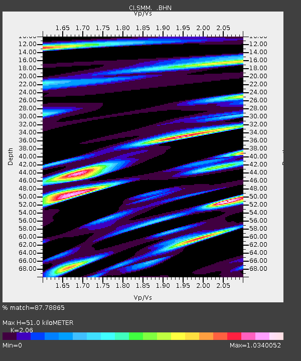
| Estimated Moho Depth: |
51.0 km |
| Estimated Crust Vp/Vs: |
2.06 |
| Assumed Crust Vp: |
6.1 km/s |
| Estimated Crust Vs: |
2.961 km/s |
| Estimated Crust Poisson's Ratio: |
0.35 |
|
| Radial Match: |
87.78865 % |
| Radial Bump: |
400 |
| Transverse Match: |
84.45465 % |
| Transverse Bump: |
400 |
| SOD ConfigId: |
2564 |
| Insert Time: |
2010-02-26 01:31:06.636 +0000 |
| GWidth: |
2.5 |
| Max Bumps: |
400 |
| Tol: |
0.001 |
|
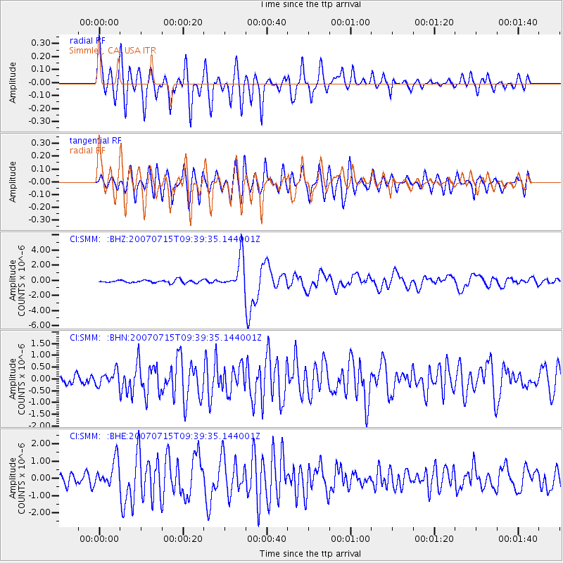
Signal To Noise
| Channel | StoN | STA | LTA |
| CI:SMM: :BHN:20070715T09:39:35.144001Z | 1.4957144 | 2.9594707E-7 | 1.9786337E-7 |
| CI:SMM: :BHE:20070715T09:39:35.144001Z | 3.0786138 | 7.600862E-7 | 2.4689234E-7 |
| CI:SMM: :BHZ:20070715T09:39:35.144001Z | 11.869544 | 2.2074285E-6 | 1.8597416E-7 |
| Arrivals |
| Ps | 9.0 SECOND |
| PpPs | 25 SECOND |
| PsPs/PpSs | 34 SECOND |


