You are here: Home > Network List > TA - USArray Transportable Network (new EarthScope stations) Stations List
> Station D15A Lincoln, MT, USA > Earthquake Result Viewer
D15A Lincoln, MT, USA - Earthquake Result Viewer
| Earthquake location: |
Kamchatka Peninsula, Russia |
| Earthquake latitude/longitude: |
52.1/157.3 |
| Earthquake time(UTC): |
2007/05/30 (150) 20:22:12 GMT |
| Earthquake Depth: |
116 km |
| Earthquake Magnitude: |
6.4 MB, 6.4 MW, 6.4 MW |
| Earthquake Catalog/Contributor: |
WHDF/NEIC |
|
| Network: |
TA USArray Transportable Network (new EarthScope stations) |
| Station: |
D15A Lincoln, MT, USA |
| Lat/Lon: |
47.04 N/112.52 W |
| Elevation: |
1593 m |
|
| Distance: |
55.0 deg |
| Az: |
56.573 deg |
| Baz: |
311.224 deg |
| Ray Param: |
0.064696215 |
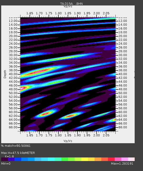
| Estimated Moho Depth: |
47.5 km |
| Estimated Crust Vp/Vs: |
1.60 |
| Assumed Crust Vp: |
6.353 km/s |
| Estimated Crust Vs: |
3.971 km/s |
| Estimated Crust Poisson's Ratio: |
0.18 |
|
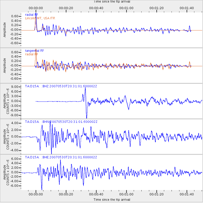
| Radial Match: |
90.50861 % |
| Radial Bump: |
400 |
| Transverse Match: |
85.62818 % |
| Transverse Bump: |
400 |
| SOD ConfigId: |
2564 |
| Insert Time: |
2010-03-06 05:01:03.633 +0000 |
| GWidth: |
2.5 |
| Max Bumps: |
400 |
| Tol: |
0.001 |
|
Signal To Noise
| Channel | StoN | STA | LTA |
| TA:D15A: :BHN:20070530T20:31:01.600002Z | 26.386189 | 1.6948052E-6 | 6.423077E-8 |
| TA:D15A: :BHE:20070530T20:31:01.600002Z | 34.326588 | 2.5980014E-6 | 7.568482E-8 |
| TA:D15A: :BHZ:20070530T20:31:01.600002Z | 75.3078 | 4.5562865E-6 | 6.050219E-8 |
| Arrivals |
| Ps | 4.7 SECOND |
| PpPs | 18 SECOND |
| PsPs/PpSs | 23 SECOND |


