You are here: Home > Network List > TA - USArray Transportable Network (new EarthScope stations) Stations List
> Station D15A Lincoln, MT, USA > Earthquake Result Viewer
D15A Lincoln, MT, USA - Earthquake Result Viewer
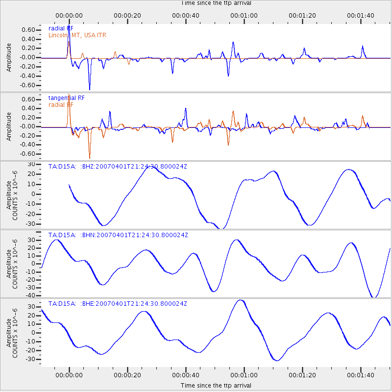
| Earthquake location: |
Solomon Islands |
| Earthquake latitude/longitude: |
-7.3/155.7 |
| Earthquake time(UTC): |
2007/04/01 (091) 21:11:33 GMT |
| Earthquake Depth: |
10 km |
| Earthquake Magnitude: |
6.3 MB |
| Earthquake Catalog/Contributor: |
WHDF/NEIC |
|
| Network: |
TA USArray Transportable Network (new EarthScope stations) |
| Station: |
D15A Lincoln, MT, USA |
| Lat/Lon: |
47.04 N/112.52 W |
| Elevation: |
1593 m |
|
| Distance: |
96.5 deg |
| Az: |
43.471 deg |
| Baz: |
266.281 deg |
| Ray Param: |
0.04050502 |
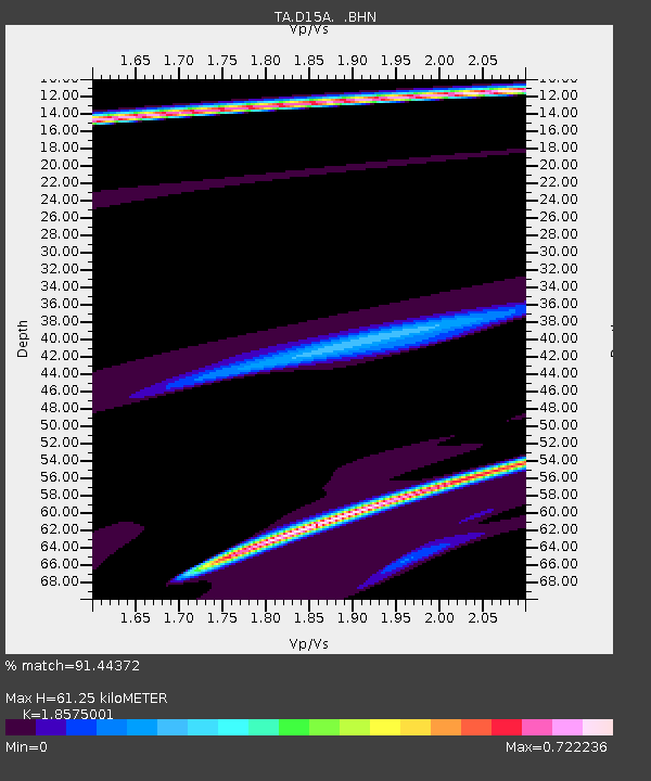
| Estimated Moho Depth: |
61.25 km |
| Estimated Crust Vp/Vs: |
1.86 |
| Assumed Crust Vp: |
6.353 km/s |
| Estimated Crust Vs: |
3.42 km/s |
| Estimated Crust Poisson's Ratio: |
0.30 |
|
| Radial Match: |
91.44372 % |
| Radial Bump: |
400 |
| Transverse Match: |
39.79156 % |
| Transverse Bump: |
237 |
| SOD ConfigId: |
2564 |
| Insert Time: |
2010-03-06 05:01:07.563 +0000 |
| GWidth: |
2.5 |
| Max Bumps: |
400 |
| Tol: |
0.001 |
|
Signal To Noise
| Channel | StoN | STA | LTA |
| TA:D15A: :BHN:20070401T21:24:30.800024Z | 0.57372856 | 1.0821013E-5 | 1.886086E-5 |
| TA:D15A: :BHE:20070401T21:24:30.800024Z | 0.6821045 | 1.3902111E-5 | 2.0381203E-5 |
| TA:D15A: :BHZ:20070401T21:24:30.800024Z | 2.2921162 | 3.1446227E-5 | 1.3719299E-5 |
| Arrivals |
| Ps | 8.4 SECOND |
| PpPs | 27 SECOND |
| PsPs/PpSs | 35 SECOND |


