You are here: Home > Network List > RV - Regional Alberta Seismic Observatory for Earthquake Studies Network Stations List
> Station WTMTA White Mountain Lookout Tower, AB > Earthquake Result Viewer
WTMTA White Mountain Lookout Tower, AB - Earthquake Result Viewer
| Earthquake location: |
Off East Coast Of Honshu, Japan |
| Earthquake latitude/longitude: |
37.5/144.0 |
| Earthquake time(UTC): |
2017/10/06 (279) 07:59:33 GMT |
| Earthquake Depth: |
10 km |
| Earthquake Magnitude: |
6.0 Mww |
| Earthquake Catalog/Contributor: |
NEIC PDE/us |
|
| Network: |
RV Regional Alberta Seismic Observatory for Earthquake Studies Network |
| Station: |
WTMTA White Mountain Lookout Tower, AB |
| Lat/Lon: |
55.69 N/119.24 W |
| Elevation: |
1030 m |
|
| Distance: |
63.5 deg |
| Az: |
38.916 deg |
| Baz: |
298.047 deg |
| Ray Param: |
0.059533313 |
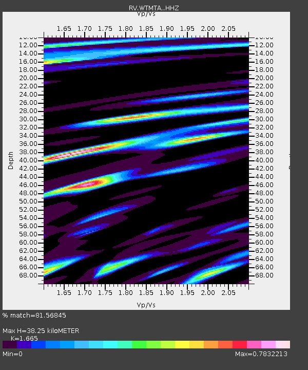
| Estimated Moho Depth: |
38.25 km |
| Estimated Crust Vp/Vs: |
1.66 |
| Assumed Crust Vp: |
6.161 km/s |
| Estimated Crust Vs: |
3.7 km/s |
| Estimated Crust Poisson's Ratio: |
0.22 |
|
| Radial Match: |
81.56845 % |
| Radial Bump: |
400 |
| Transverse Match: |
66.840866 % |
| Transverse Bump: |
400 |
| SOD ConfigId: |
13570011 |
| Insert Time: |
2019-04-28 22:41:19.740 +0000 |
| GWidth: |
2.5 |
| Max Bumps: |
400 |
| Tol: |
0.001 |
|

Signal To Noise
| Channel | StoN | STA | LTA |
| RV:WTMTA: :HHZ:20171006T08:09:31.84999Z | 15.587675 | 3.5401754E-6 | 2.2711376E-7 |
| RV:WTMTA: :HHN:20171006T08:09:31.84999Z | 0.959113 | 3.5037777E-7 | 3.6531438E-7 |
| RV:WTMTA: :HHE:20171006T08:09:31.84999Z | 3.212633 | 9.099179E-7 | 2.832312E-7 |
| Arrivals |
| Ps | 4.3 SECOND |
| PpPs | 16 SECOND |
| PsPs/PpSs | 20 SECOND |


