You are here: Home > Network List > S - Seismographs in Schools Projects Stations List
> Station AUALC St Philip's College, Alice Springs, NT > Earthquake Result Viewer
AUALC St Philip's College, Alice Springs, NT - Earthquake Result Viewer
| Earthquake location: |
Off East Coast Of Honshu, Japan |
| Earthquake latitude/longitude: |
37.5/144.0 |
| Earthquake time(UTC): |
2017/10/06 (279) 07:59:33 GMT |
| Earthquake Depth: |
10 km |
| Earthquake Magnitude: |
6.0 Mww |
| Earthquake Catalog/Contributor: |
NEIC PDE/us |
|
| Network: |
S Seismographs in Schools Projects |
| Station: |
AUALC St Philip's College, Alice Springs, NT |
| Lat/Lon: |
23.69 S/133.88 E |
| Elevation: |
573 m |
|
| Distance: |
61.6 deg |
| Az: |
190.501 deg |
| Baz: |
9.1 deg |
| Ray Param: |
0.06078162 |
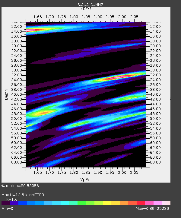
| Estimated Moho Depth: |
13.5 km |
| Estimated Crust Vp/Vs: |
1.60 |
| Assumed Crust Vp: |
6.518 km/s |
| Estimated Crust Vs: |
4.074 km/s |
| Estimated Crust Poisson's Ratio: |
0.18 |
|
| Radial Match: |
80.53056 % |
| Radial Bump: |
400 |
| Transverse Match: |
58.279015 % |
| Transverse Bump: |
400 |
| SOD ConfigId: |
13570011 |
| Insert Time: |
2019-04-28 22:41:22.862 +0000 |
| GWidth: |
2.5 |
| Max Bumps: |
400 |
| Tol: |
0.001 |
|

Signal To Noise
| Channel | StoN | STA | LTA |
| S:AUALC: :HHZ:20171006T08:09:19.529983Z | 7.5107737 | 1.5112473E-6 | 2.0121061E-7 |
| S:AUALC: :HHN:20171006T08:09:19.529983Z | 2.3223937 | 6.812163E-7 | 2.933251E-7 |
| S:AUALC: :HHE:20171006T08:09:19.529983Z | 0.8197173 | 1.877641E-7 | 2.290596E-7 |
| Arrivals |
| Ps | 1.3 SECOND |
| PpPs | 5.1 SECOND |
| PsPs/PpSs | 6.4 SECOND |


