You are here: Home > Network List > TA - USArray Transportable Network (new EarthScope stations) Stations List
> Station B20K Meade River, AK, USA > Earthquake Result Viewer
B20K Meade River, AK, USA - Earthquake Result Viewer
| Earthquake location: |
Off East Coast Of Honshu, Japan |
| Earthquake latitude/longitude: |
37.5/144.0 |
| Earthquake time(UTC): |
2017/10/06 (279) 07:59:33 GMT |
| Earthquake Depth: |
10 km |
| Earthquake Magnitude: |
6.0 Mww |
| Earthquake Catalog/Contributor: |
NEIC PDE/us |
|
| Network: |
TA USArray Transportable Network (new EarthScope stations) |
| Station: |
B20K Meade River, AK, USA |
| Lat/Lon: |
70.01 N/157.16 W |
| Elevation: |
75 m |
|
| Distance: |
44.7 deg |
| Az: |
24.731 deg |
| Baz: |
255.387 deg |
| Ray Param: |
0.07173446 |
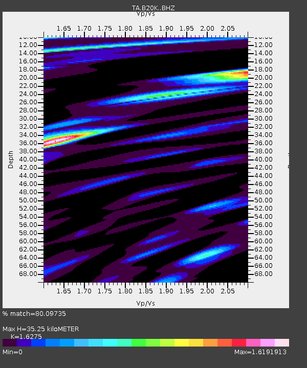
| Estimated Moho Depth: |
35.25 km |
| Estimated Crust Vp/Vs: |
1.63 |
| Assumed Crust Vp: |
6.048 km/s |
| Estimated Crust Vs: |
3.716 km/s |
| Estimated Crust Poisson's Ratio: |
0.20 |
|
| Radial Match: |
80.09735 % |
| Radial Bump: |
400 |
| Transverse Match: |
68.74858 % |
| Transverse Bump: |
400 |
| SOD ConfigId: |
13570011 |
| Insert Time: |
2019-04-28 22:42:01.968 +0000 |
| GWidth: |
2.5 |
| Max Bumps: |
400 |
| Tol: |
0.001 |
|

Signal To Noise
| Channel | StoN | STA | LTA |
| TA:B20K: :BHZ:20171006T08:07:15.175002Z | 7.250262 | 5.2159035E-6 | 7.1940894E-7 |
| TA:B20K: :BHN:20171006T08:07:15.175002Z | 1.2430738 | 6.489249E-7 | 5.220325E-7 |
| TA:B20K: :BHE:20171006T08:07:15.175002Z | 3.0765636 | 1.8908914E-6 | 6.146115E-7 |
| Arrivals |
| Ps | 3.9 SECOND |
| PpPs | 14 SECOND |
| PsPs/PpSs | 18 SECOND |


