You are here: Home > Network List > TA - USArray Transportable Network (new EarthScope stations) Stations List
> Station B21K Ikpikpuk River, AK, USA > Earthquake Result Viewer
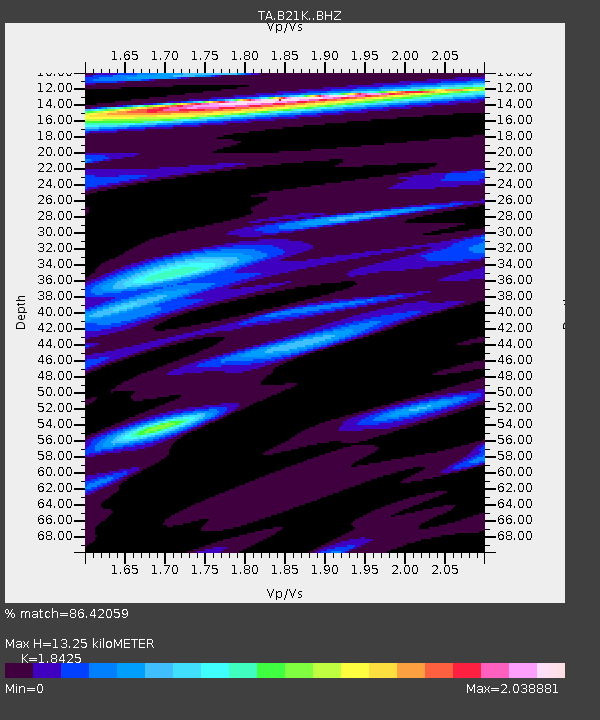
B21K Ikpikpuk River, AK, USA - Earthquake Result Viewer
| Earthquake location: |
Off East Coast Of Honshu, Japan |
| Earthquake latitude/longitude: |
37.5/144.0 |
| Earthquake time(UTC): |
2017/10/06 (279) 07:59:33 GMT |
| Earthquake Depth: |
10 km |
| Earthquake Magnitude: |
6.0 Mww |
| Earthquake Catalog/Contributor: |
NEIC PDE/us |
|
| Network: |
TA USArray Transportable Network (new EarthScope stations) |
| Station: |
B21K Ikpikpuk River, AK, USA |
| Lat/Lon: |
69.62 N/154.61 W |
| Elevation: |
92 m |
|
| Distance: |
45.5 deg |
| Az: |
25.549 deg |
| Baz: |
258.352 deg |
| Ray Param: |
0.071232915 |
| Estimated Moho Depth: |
13.25 km |
| Estimated Crust Vp/Vs: |
1.84 |
| Assumed Crust Vp: |
6.221 km/s |
| Estimated Crust Vs: |
3.376 km/s |
| Estimated Crust Poisson's Ratio: |
0.29 |
|
| Radial Match: |
86.42059 % |
| Radial Bump: |
400 |
| Transverse Match: |
68.725716 % |
| Transverse Bump: |
400 |
| SOD ConfigId: |
13570011 |
| Insert Time: |
2019-04-28 22:42:03.809 +0000 |
| GWidth: |
2.5 |
| Max Bumps: |
400 |
| Tol: |
0.001 |
|

Signal To Noise
| Channel | StoN | STA | LTA |
| TA:B21K: :BHZ:20171006T08:07:21.300002Z | 8.809216 | 3.536265E-6 | 4.014279E-7 |
| TA:B21K: :BHN:20171006T08:07:21.300002Z | 1.5370853 | 6.585789E-7 | 4.284596E-7 |
| TA:B21K: :BHE:20171006T08:07:21.300002Z | 3.698292 | 1.3591755E-6 | 3.675144E-7 |
| Arrivals |
| Ps | 1.9 SECOND |
| PpPs | 5.7 SECOND |
| PsPs/PpSs | 7.6 SECOND |


